
The Moab You Didn’t Know About: Dinosaurs, Petroglyphs & the Desert Before the Bikes
A closer look at what came before the trails.
Words by Michele Underwood | Photos by Michele
Moab is famous for red rock, mountain biking, Jeeps, and national parks. That’s the version most people come for.
But that’s not where the story starts.
Long before slickrock trails and shuttle vans, this landscape held dinosaurs. Long before river guides and campgrounds existed, it was home to Indigenous peoples, including the Ancestral Puebloans and the Fremont culture, and later to the Ute and Diné (Navajo), who carved stories and symbols into stone. Before tourism reshaped the economy, uranium mining did.
You can ride here all day. You can hike the arches at sunrise. But if you slow down, there’s another Moab layered underneath it all. Think of these as the other types of adventures. You can do in Moab.
This is that version.
A Town Built on Layers
Moab didn’t become an adventure capital overnight. It was shaped slowly—by shifting geology, ancient ecosystems, human presence, extraction, and reinvention.
Every trail and overlook sits atop something older.
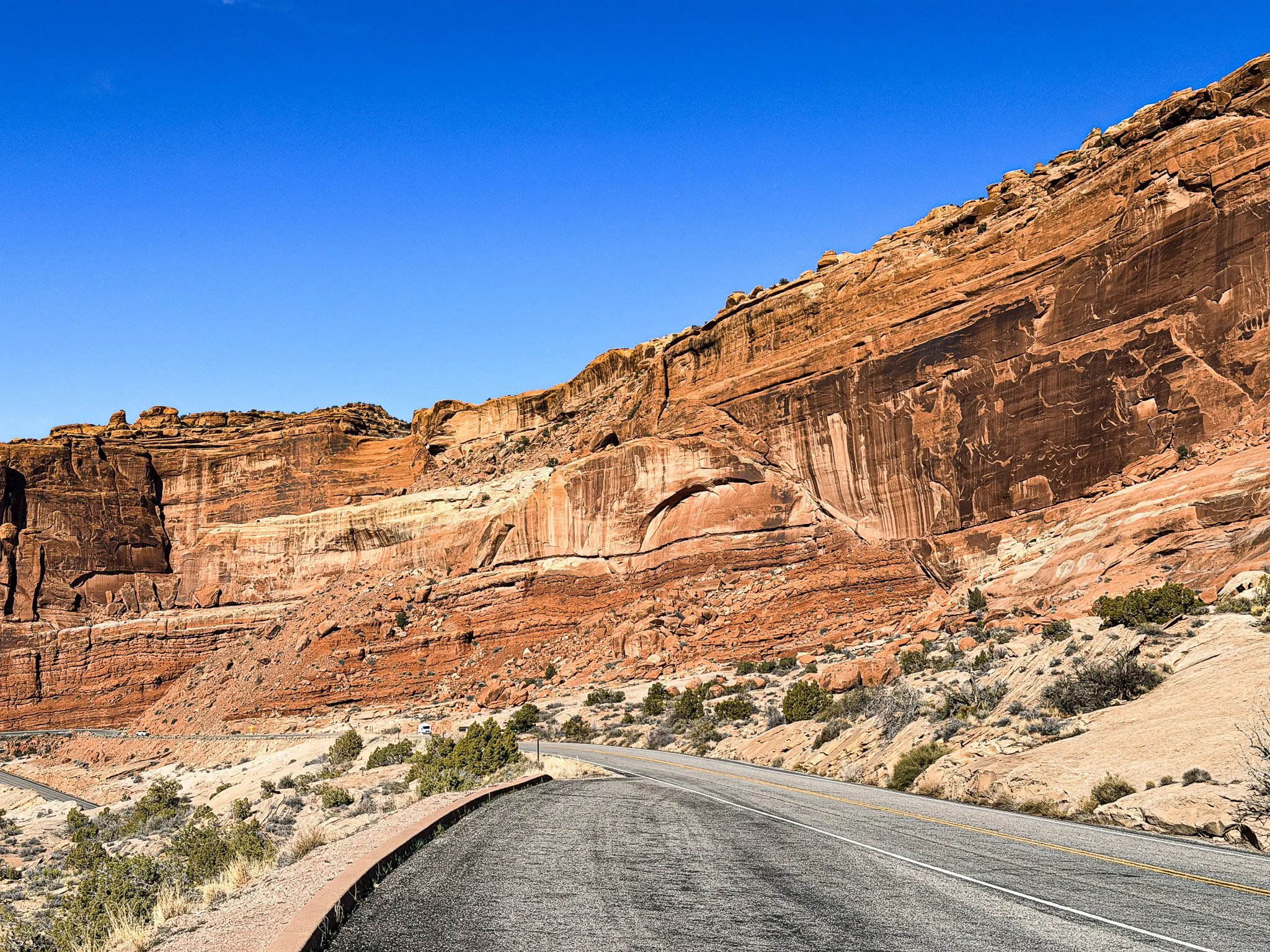
Tilted sandstone layers inside Arches National Park just beyond the visitor center, showing the surface expression of the Moab Fault.
Beneath all of it lies something structural—the Moab Fault. This massive fracture in the earth’s crust lifted and tilted entire rock layers, exposing ancient surfaces that would otherwise still be buried underground. It’s part of why dinosaur tracks, shifting color bands, and dramatic, angled cliffs are visible at all.
To learn more, read: The Moab Fault: The Crack That Shaped the Desert.
Before the Trails: Dinosaurs in the Desert
Eastern Utah lies atop the Morrison Formation, a geologic layer known worldwide for its Late Jurassic fossils. Roughly 150 million years ago, this was not a dry, wind-scoured desert. It was a landscape of rivers, floodplains, and vegetation that supported massive sauropods, carnivorous theropods, and armored dinosaurs.
Today, you can still see evidence of that world.
Dinosaur tracksites near Moab preserve footprints pressed into ancient mud. These aren’t museum replicas. They’re impressions left in soft sediment that hardened over time and were later exposed by erosion.
I recently saw this at Poison Spider, where two rock slabs that had fallen exposed the footprints of meat-eating dinosaurs. It was really neat to see these in an exposed area and not a part of a National Park or museum. They are just on a hiking trail.
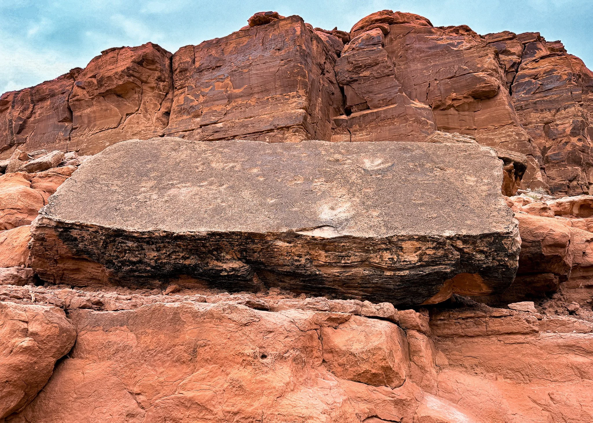
Dinosaur footprints exposed on a fallen rock slab at Poison Spider near Moab — revealed by erosion and shifting stone over time.
The landscape itself helped reveal them. The Moab Fault runs through this region, shifting and fracturing rock layers over millions of years. Combined with uplift and erosion, those movements exposed ancient surfaces that once sat buried beneath sediment.
You can even find them where you were not told they would be. You will see large dinosaur footprints at the Corona Arch. They are just everywhere underneath our feet. Some are not even exposed.
Standing there, you’re not imagining dinosaurs. You’re standing where they stepped.
The desert you ride across now was once a river system dense with vegetation and life entirely different from what you see today.
To learn more, read: Dinosaurs Near Moab: Track Sites, Fossils & Where to See Them.
The Stories in Stone: Petroglyphs Near Moab
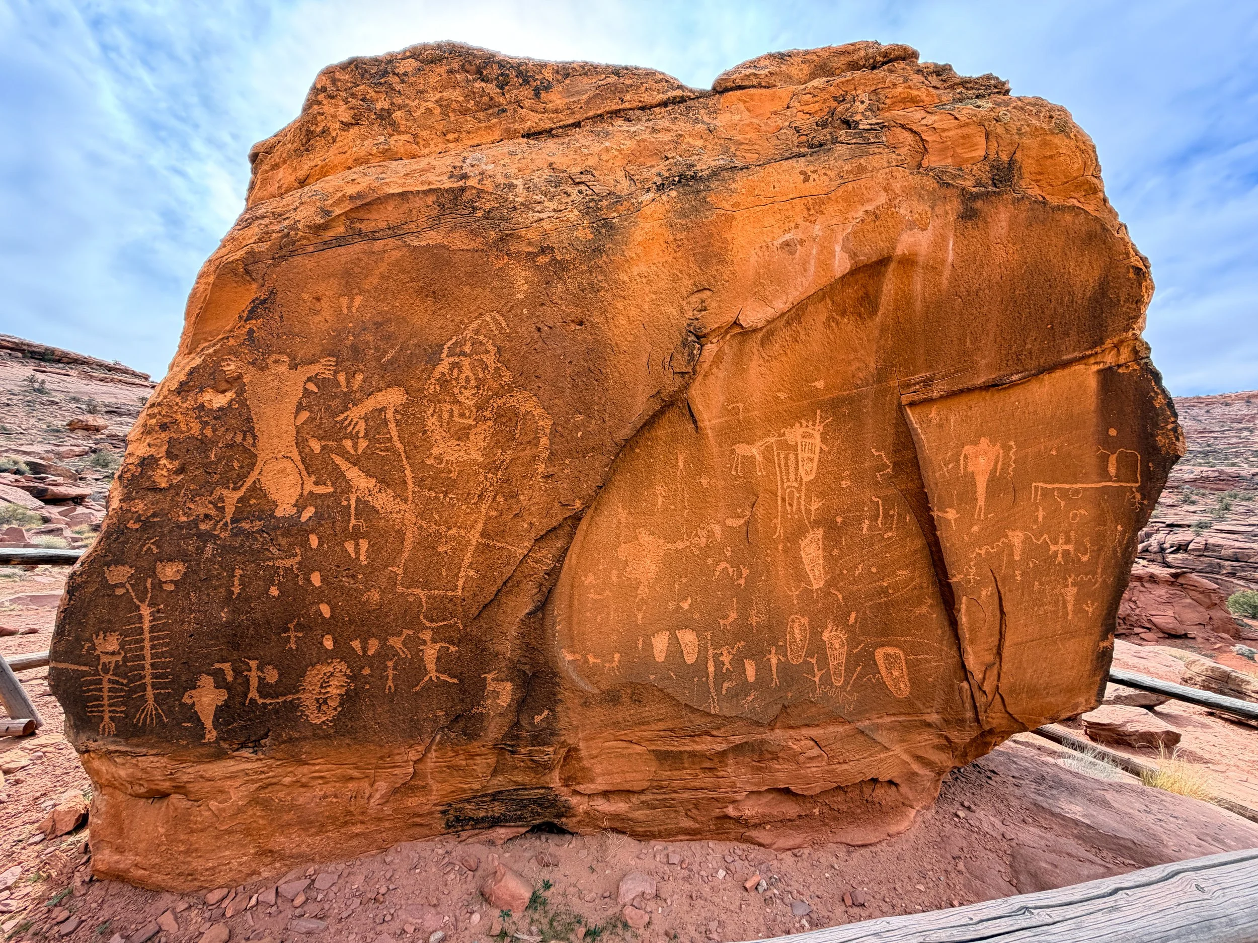
Fremont petroglyphs carved into a sandstone boulder along the Colorado River corridor near Moab, Utah. Panels like this date roughly from 300–1300 A.D.
Long after the dinosaurs disappeared, people moved through this landscape and left their own marks.
Petroglyph panels around Moab include figures attributed to the Fremont culture and later Ute peoples, with broader Ancestral Puebloan influence across southeastern Utah. Stylized human forms, animals, symbols, and abstract shapes are carved into vertical rock faces along canyon walls and river corridors.
These markings are not decorative. They carry cultural meaning and historical presence.
Many panels are visible from roads or short walks, which makes them accessible—but also vulnerable. The rock art survives because the desert is dry. Touching, tracing, or climbing on panels accelerates erosion and damages surfaces that have already endured for centuries.
Some sites have been vandalized. At Courthouse Wash, for example, portions of the panel were defaced in recent years. Efforts were made to clean and stabilize it, and in the process, additional details were revealed beneath the damage. That doesn’t make the vandalism any less harmful. Once a surface is altered, it can never fully return to what it was.
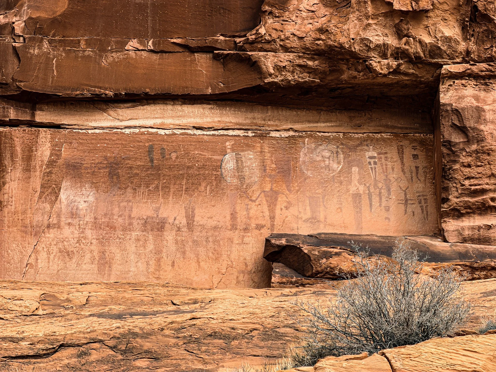
Courthouse Wash petroglyph panel near Arches National Park, Moab, Utah, featuring Fremont-style human figures carved into desert sandstone.
The same cliffs that hold climbing routes and bike trails also hold cultural memory.
To learn more, read: Petroglyphs Near Moab: Where to See Rock Art & What It Means.
The Atomic Age: Uranium and the Boom Years
Moab did not become an outdoor recreation town overnight.
In 1952, a geologist named Charles Steen struck a rich uranium deposit south of town at what became known as the Mi Vida mine. His discovery triggered one of the most dramatic economic shifts in Moab’s history.
At the time, the United States was deep in the Cold War. The Atomic Energy Commission (AEC) offered guaranteed prices and bonuses for uranium ore to fuel nuclear weapons development and atomic energy programs. Prospectors poured into southeastern Utah. Mining claims spread quickly across canyon country. What had been a small ranching and agricultural community transformed into a boomtown almost overnight.
Population surged. Motels filled. New businesses opened. Trucks hauling ore became part of the daily landscape. The desert was no longer just red rock and river — it was opportunity.
Processing mills operated along the Colorado River, including the Atlas Mill just north of town. Ore was crushed and chemically treated to extract uranium. What remained behind was mill tailings — massive piles of radioactive and chemically contaminated waste stacked along the riverbank.
Then the market shifted.
By the 1960s, federal incentives declined and uranium prices collapsed. Mines closed. Jobs disappeared. The boom slowed. Moab faced a downturn that forced reinvention.
But the physical legacy remained. The tailings pile sat beside the Colorado River for decades before a long-term federal cleanup began. Today, contaminated material from the former mill site is being relocated by rail to a disposal cell near Crescent Junction as part of one of the largest environmental remediation projects in the region.
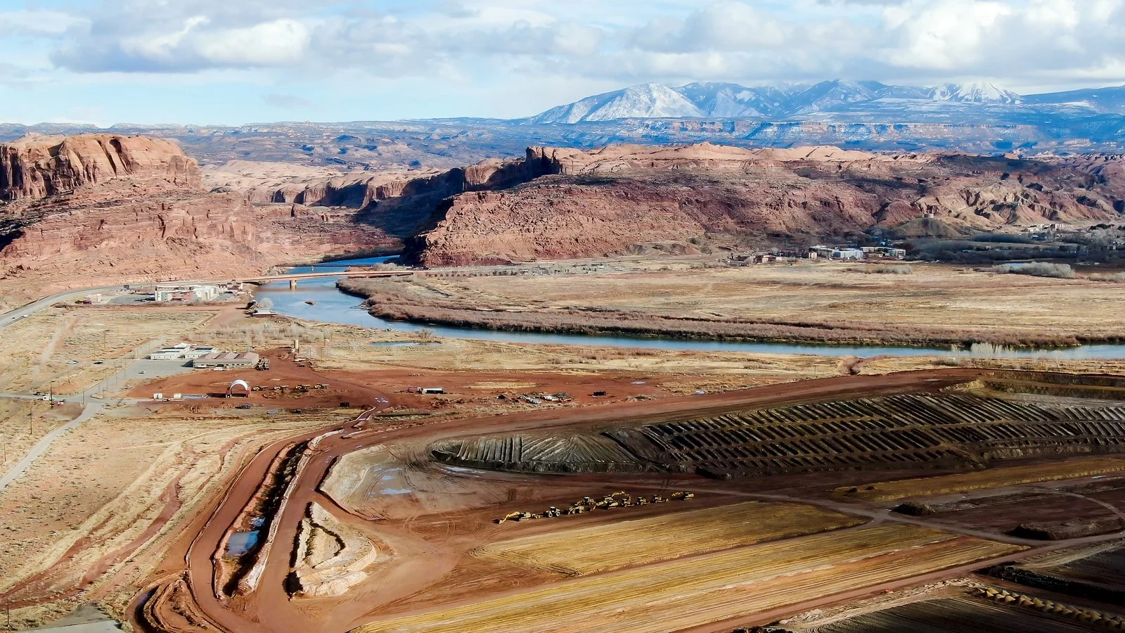
Cleanup and containment work at the former Atlas Uranium Mill site along the Colorado River near Moab, Utah — part of the long-term remediation of Cold War–era mill tailings.
Over time, tourism and outdoor recreation replaced extraction as the dominant industry.
The red rock didn’t change. The economy did.
To learn more, read: Moab’s Uranium Boom: How the Atomic Age Reshaped the Desert Town.
Industry in Plain Sight: Potash and the Blue Ponds
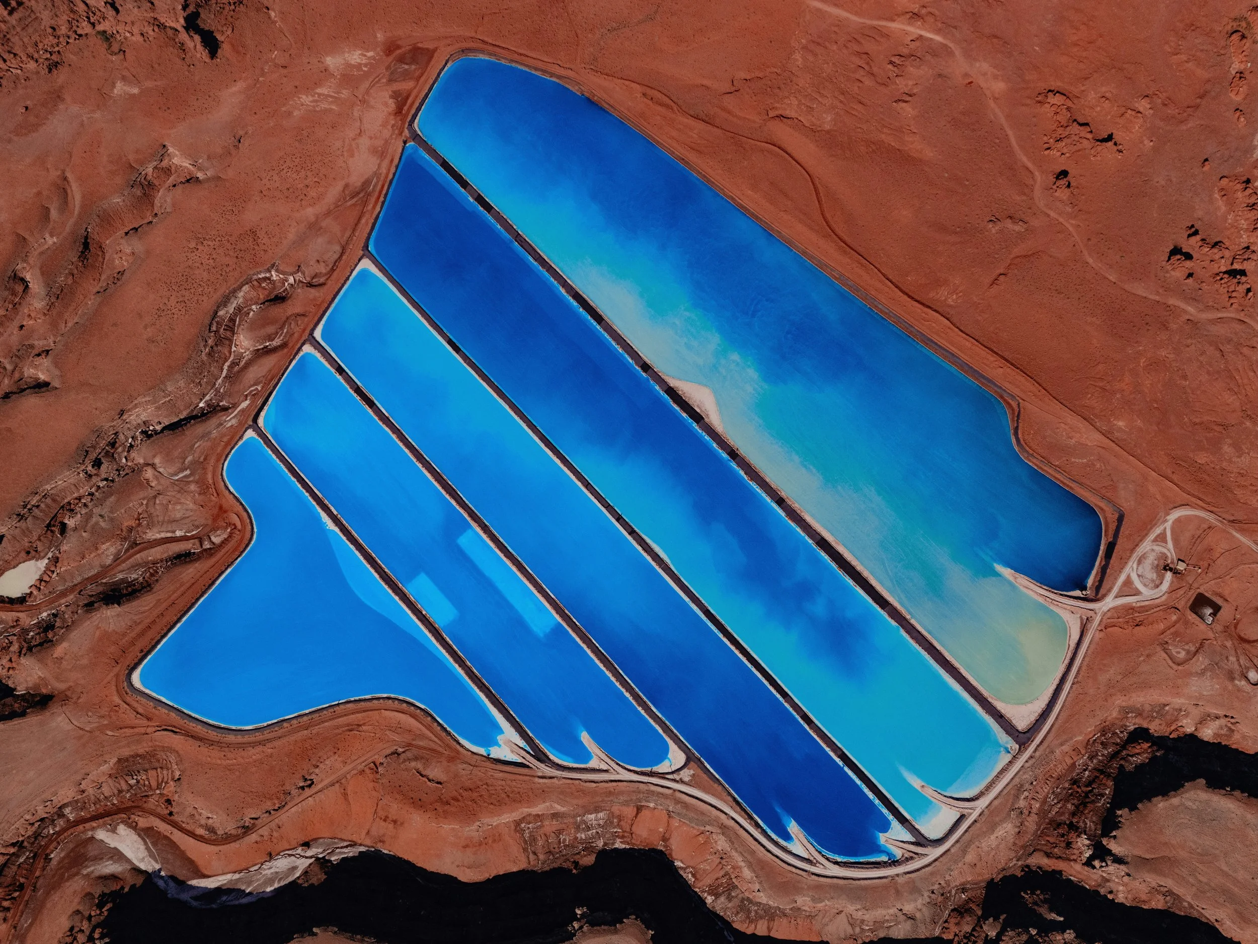
Aerial view of potash evaporation ponds along Potash Road near Moab, Utah, where brine is evaporated to extract potassium minerals used in fertilizer production. Photo by Karsten Winegeart.
Drive west of town along the Colorado River on Potash Road (UT‑279), and you’ll see bright blue evaporation ponds carved into the desert floor.
Those pools are part of potash extraction—minerals used primarily in fertilizer production. Brine is pumped from deep underground, evaporated under the desert sun, and processed nearby.
It’s a striking visual contrast: industrial geometry set against sculpted sandstone cliffs.
Moab isn’t only recreation. Just beyond the trailheads and river put‑ins, it remains a working landscape.
To learn more, read: Potash Ponds Near Moab: What Those Bright Blue Pools Really Are
The Moab Most People See
Someone I spoke with at Arches National Park told me that before the park was established, Moab was a very different place. Arches was first designated a National Monument in 1929 and later redesignated as a National Park in 1971. That recognition helped put the town on the map, and local advocacy played a role in shaping that shift. The park changed Moab.
Today, Moab is synonymous with mountain biking, river running, hiking, climbing, and national parks. Trails lace the mesas. Jeeps crawl over slickrock. People from all over come to photograph Delicate Arch.
That version of Moab is real.
But it exists on top of older layers.
Dinosaurs shaped the geology. Indigenous cultures marked the cliffs. Uranium reshaped the economy. Extraction left visible traces. Recreation followed.
When you ride here or hike here, you’re moving through all of it at once.
Why This Matters
Understanding the layers changes how the place feels.
The rock is not just scenery. The town is not just a trailhead. The desert is not empty.
Moab holds stories that stretch from prehistoric ecosystems to atomic-era ambition to modern adventure culture.
You can come for the biking. You can come for the parks.
But there’s another Moab beneath the one on postcards.
And once you see it, you don’t really unsee it.
More in the Moab Series
This article is part of an ongoing Moab series exploring the landscape from multiple angles — history, geology, riding, and national parks.
Dinosaurs Near Moab: Track Sites, Fossils & Where to See Them
Petroglyphs Near Moab: Where to See Rock Art & What It Means
Moab’s Uranium Boom: How the Atomic Age Reshaped the Desert Town
Potash Ponds Near Moab: What Those Bright Blue Pools Really Are
Michele Underwood writes Overland Girl, where she shares firsthand travel experiences across the American West — from desert landscapes and national parks to small towns layered with history. Her work blends movement, place, and the stories that shape them.

Some posts may include affiliate links to products or services she uses on the road. If you choose to purchase through those links, she may earn a small commission at no additional cost to you. It helps support continued travel and storytelling. She only links to items she personally uses or would use herself.