
The Moab Fault: The Crack That Shaped the Desert
A vertical shift in the earth that explains the cliffs, the tracks, and the layers beneath Moab.
Words by Michele Underwood | Photos by Michele
After a few days in Moab, I kept noticing something that didn’t feel natural.
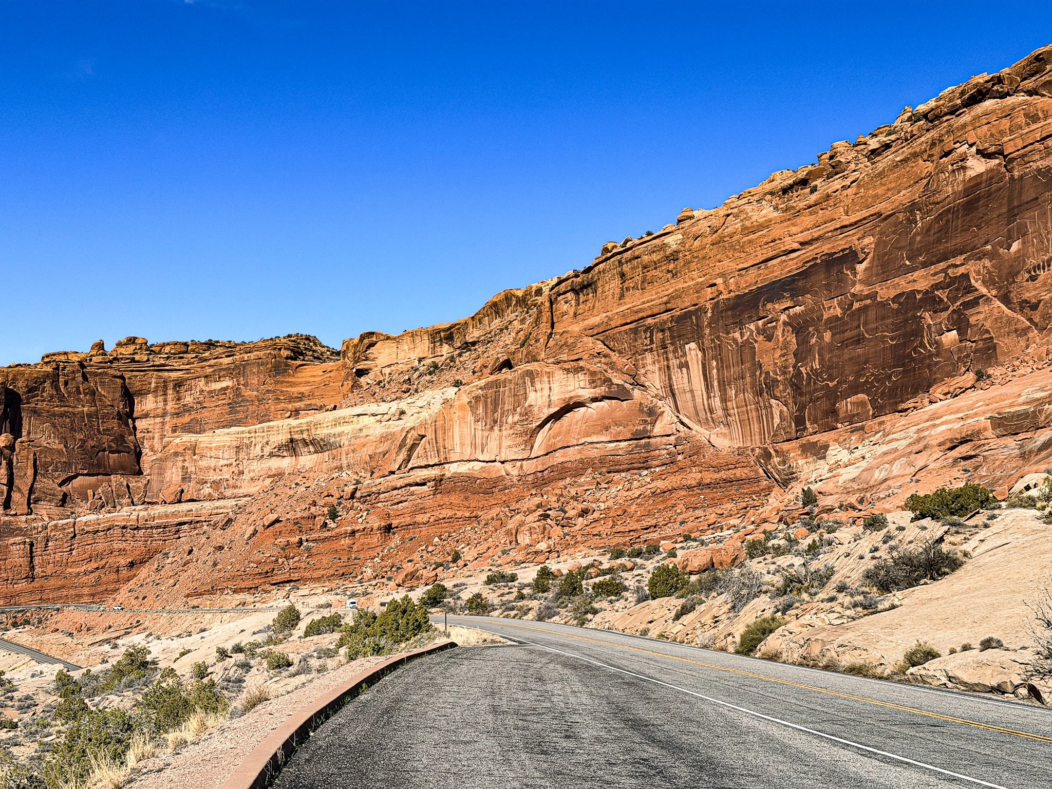
Entire sections of rock were tilted at sharp angles — like the front of the Titanic lifting out of the water before it went down. Massive slabs looked as if they were pushed upward and frozen mid‑motion.
[Photo suggestion: Angled rock layers along Highway 191 just north of town. Wide shot showing tilt.]
You see it clearly along Highway 191 north of Moab. Huge walls of rock sit at angles that don’t look stable.
You can drive right past it and never realize what you’re looking at.
What you’re seeing is the Moab Fault — a massive fracture in the earth’s crust where rock layers have shifted vertically by thousands of feet over millions of years.
The Moab Fault runs just outside town and cuts through the broader Moab valley landscape.
It’s not dramatic in the way an arch is dramatic. It’s subtle. Linear. A seam in the desert.
But it explains a lot.
What Is the Moab Fault?
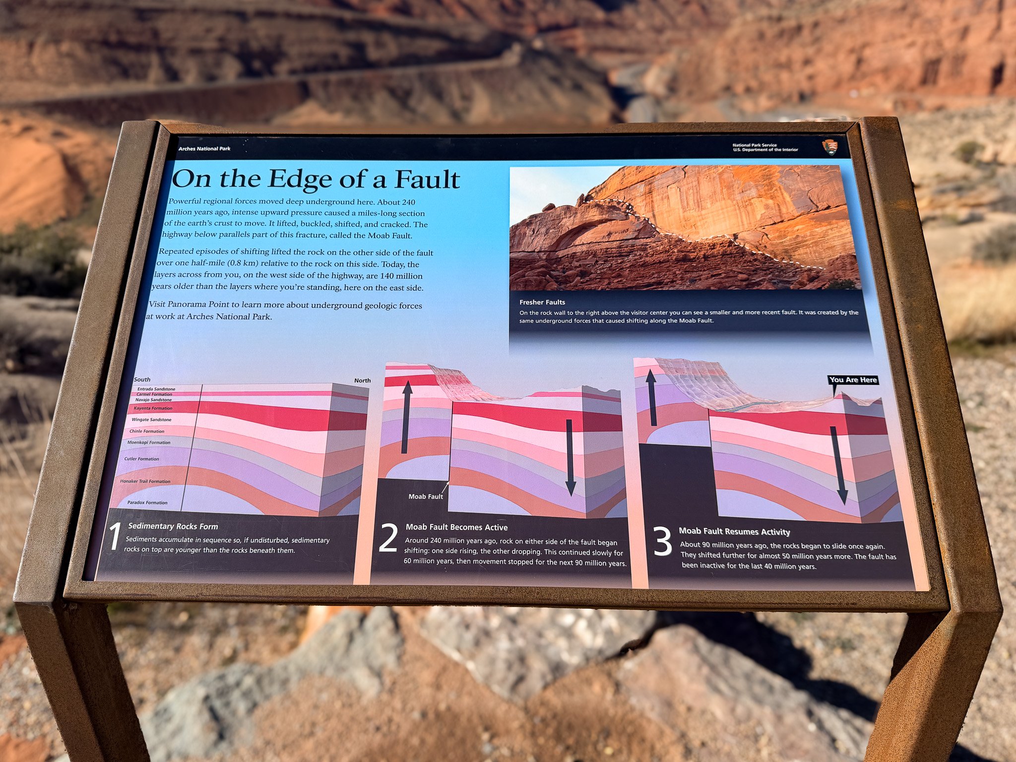
An interpretive sign inside Arches National Park explains how the Moab Fault shifted rock layers over millions of years.
A fault is a fracture in the earth where blocks of rock move relative to each other. In Moab’s case, movement along this fault lifted one side of the landscape thousands of feet higher than the other.
That vertical displacement created dramatic relief and exposed cross‑sections of rock layers that would otherwise remain less visible.
The Morrison Formation — the same layer that preserves many dinosaur tracks in eastern Utah — is widespread across the region. Its exposure isn’t caused by the Moab Fault alone.
Fresh fault line cutting through layered red sandstone cliffs inside Arches National Park near the visitor center, illustrating recent movement along the Moab Fault system.
Instead, uplift of the Colorado Plateau, movement along faults like this one, and millions of years of erosion all worked together to reveal those ancient surfaces.
The Moab Fault is part of that structural story — not the only reason tracks are visible, but one of the forces that shaped how the layers appear today.
Why the Rocks Tilt Like That
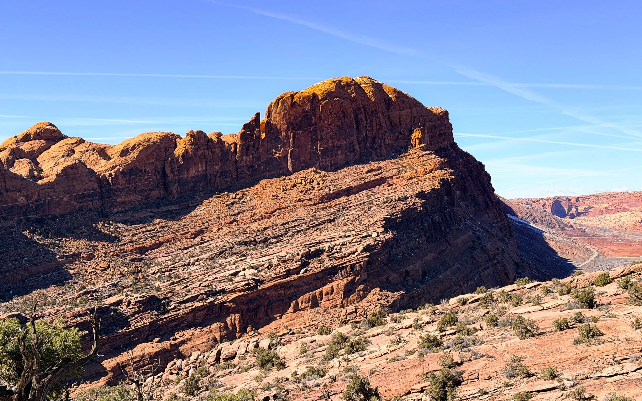
Tilted sedimentary layers just north of Moab — the dramatic “Titanic” effect created by fault movement, salt collapse, and uplift beneath the Colorado Plateau.
The dramatic angles — the “Titanic” effect — are influenced not just by the fault, but also by what lies deep underground.
Moab sits within the Paradox Basin, which contains thick deposits of buried salt left behind by an ancient inland sea. Salt behaves very differently from solid rock. Over millions of years, it can slowly flow under pressure, shift position, and even dissolve when groundwater moves through it.
Salt was already shaping how explorers understood this landscape. In 1776, members of the Domínguez–Escalante Expedition — including Fray Silvestre Vélez de Escalante — were traveling through a region where exposed salt deposits were common. When they looked east and saw the distant peaks capped in white, they assumed it was more of the same. They named the range Sierra de la Sal — “Mountains of Salt” — not realizing the white caps were snow rising high above the desert floor.
When underground salt moved or collapsed, the rock layers above it sagged, folded, and tilted.
So what you’re seeing is the result of:
[Photo suggestion: Find a rock face where sediment layers are clearly slanted instead of horizontal. Shoot from the side so the lines of the layers angle diagonally across the frame, emphasizing the tilt rather than a flat-on view.]
Vertical movement along the Moab Fault
Regional uplift of the Colorado Plateau
Salt movement beneath the surface
Ongoing erosion
It’s geology in motion — just slowed down to a scale we can’t easily perceive.
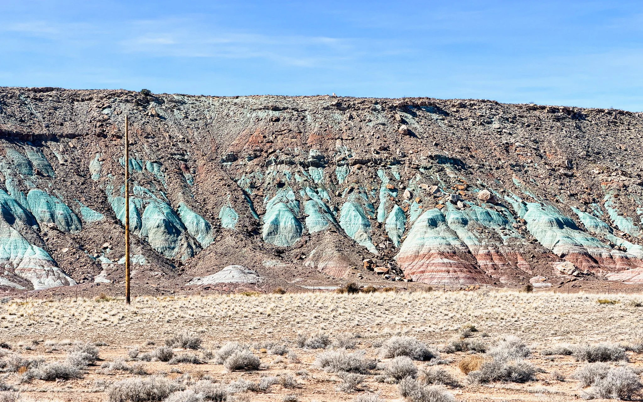
Why the Rocks Are Different Colors
If you look closely around Moab, the cliffs aren’t one solid shade of red.
[Photo suggestion: Cliff face showing red, green, and cream bands in one frame.] You’ll see bands of cream, deep rust, green, blue‑gray, and even purple running through the walls.
Those colors represent different rock formations — each laid down in a different environment at a different time.
Deep red sandstone (like Entrada and Wingate) formed in ancient desert dune systems. The red color comes from iron minerals that oxidized — essentially rusting — over time.
Green and blue‑gray layers often belong to the Morrison Formation, created in river and floodplain environments during the Late Jurassic (roughly 156–146 million years ago). Clay minerals and different iron chemistry give these layers their cooler tones.
Purple and mottled streaks reflect changing groundwater conditions long after the rock formed, altering iron minerals within the stone.
Banded hills near Utahraptor State Park showing green, red, and cream layers of the Morrison Formation — floodplain mudstones and sandstones stained by varying iron chemistry.
What you’re seeing is not just color — it’s a vertical timeline.
Desert.
River.
Desert.
Floodplain.
Stacked over hundreds of millions of years.
The Moab Fault lifted sections of that stack. Salt movement tilted and warped it. Erosion stripped it clean.
Instead of being buried underground, those layers are exposed — like a cross‑section of deep time running across the desert walls.
How Did the Colors Last This Long?
It’s easy to assume those greens and reds were added recently because some bands look almost spray‑painted onto the rock. But the color isn’t surface paint — it’s mineral chemistry locked into the stone.
The reds come from iron that oxidized (rusted) when exposed to oxygen millions of years ago. Once iron minerals oxidize inside sediment and harden into rock, that color becomes part of the structure itself.
The green and blue‑gray tones often reflect reduced iron — iron that formed in wetter, oxygen‑poor environments like floodplains. When those sediments lithified into rock, the chemical state of the minerals was preserved.
Desert climates help protect those colors. With low rainfall and limited vegetation, there’s less chemical weathering to strip or bleach the minerals away. What you’re seeing isn’t fresh pigment.
It’s ancient chemistry — stabilized, hardened, and exposed by erosion.
There’s another layer you may notice too: a dark, almost black coating on some rock faces.
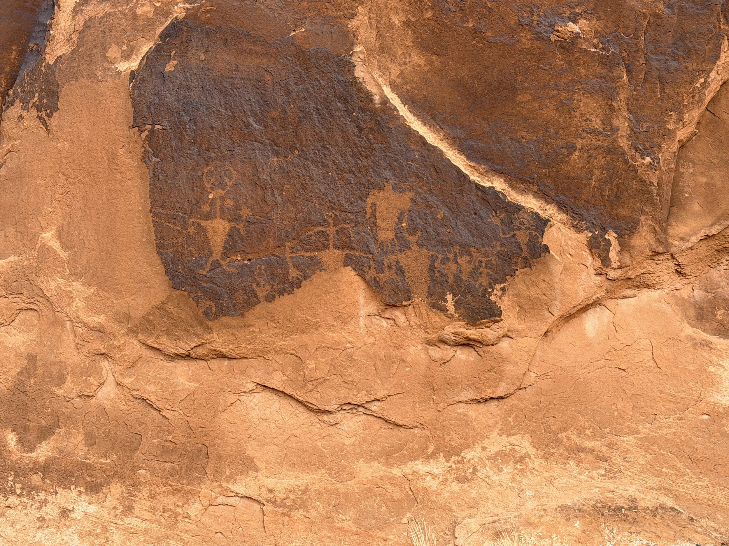
Fremont petroglyphs at the Moab Golf Course site — carved through dark desert varnish to reveal the lighter sandstone beneath, creating the strong contrast that allows the figures to stand out centuries later.
That’s called desert varnish — a thin surface layer made of clay minerals mixed with manganese and iron oxides. It forms extremely slowly, sometimes taking thousands of years to build up a thin film.
When people carved petroglyphs into canyon walls, they chipped through that dark varnish to reveal the lighter rock beneath. That contrast is why the figures stand out so clearly.
So in one cliff face you can sometimes see three timelines at once: the original sediment color, the mineral chemistry that altered it, and the desert varnish that slowly coated it over centuries.
The landscape isn’t painted.
It’s layered — chemically, structurally, and culturally.
What It Changes
Once you understand the fault, the landscape stops feeling random.
The cliffs aren’t just scenic. They’re shifted earth.
The tilted slabs aren’t unstable accidents. They’re the result of pressure, fracture, and movement over immense spans of time.
Moab isn’t just layered in history.
It’s physically fractured — lifted, tilted, and slowly revealed.
And now when you drive past those angled walls outside Arches, you won’t just see rock.
You’ll see motion frozen in place.
More in the Moab Series
This article is part of an ongoing Moab series exploring the landscape from multiple angles — history, geology, riding, and national parks.
The Moab You Didn’t Know About: Dinosaurs, Petroglyphs & the Desert Before the Bikes
Dinosaurs Near Moab: Track Sites, Fossils & Where to See Them
Petroglyphs Near Moab: Where to See Rock Art & What It Means
Moab’s Uranium Boom: How the Atomic Age Reshaped the Desert Town
Potash Ponds Near Moab: What Those Bright Blue Pools Really Are
Michele Underwood writes Overland Girl, where she shares firsthand travel experiences across the American West — from desert landscapes and national parks to small towns layered with history. Her work blends movement, place, and the stories that shape them.

Some posts may include affiliate links to products or services she uses on the road. If you choose to purchase through those links, she may earn a small commission at no additional cost to you. It helps support continued travel and storytelling. She only links to items she personally uses or would use herself.