
Petroglyphs Near Moab: Where to See Rock Art & What It Means
Where to find Moab’s ancient rock art — and the history behind who created it, how old it is, and what it represents.
Words by Michele Underwood | Photos by Michele
Moab is known for mountain biking, national parks, and red rock. It’s why I’m here.
But there’s another side to this place.
While I was visiting Western Colorado, I learned that this part of the country is filled with petroglyphs and pictographs created by prehistoric peoples, some dating back to 500 A.D.
I visited one of the petroglyph sites just outside town yesterday. It wasn’t a long hike. It wasn’t dramatic. It was quiet. The panel stretches across a sandstone wall that rises along the road—figures with wide eyes, animals, abstract shapes—carved into rock that has held them for centuries.
It was the first time I came face-to-face with art that old, still out in the open desert.
If you’re visiting Moab, these sites are worth taking time out of your day to explore. Most are right off the road.
Petroglyphs vs. Pictographs: What’s the Difference?
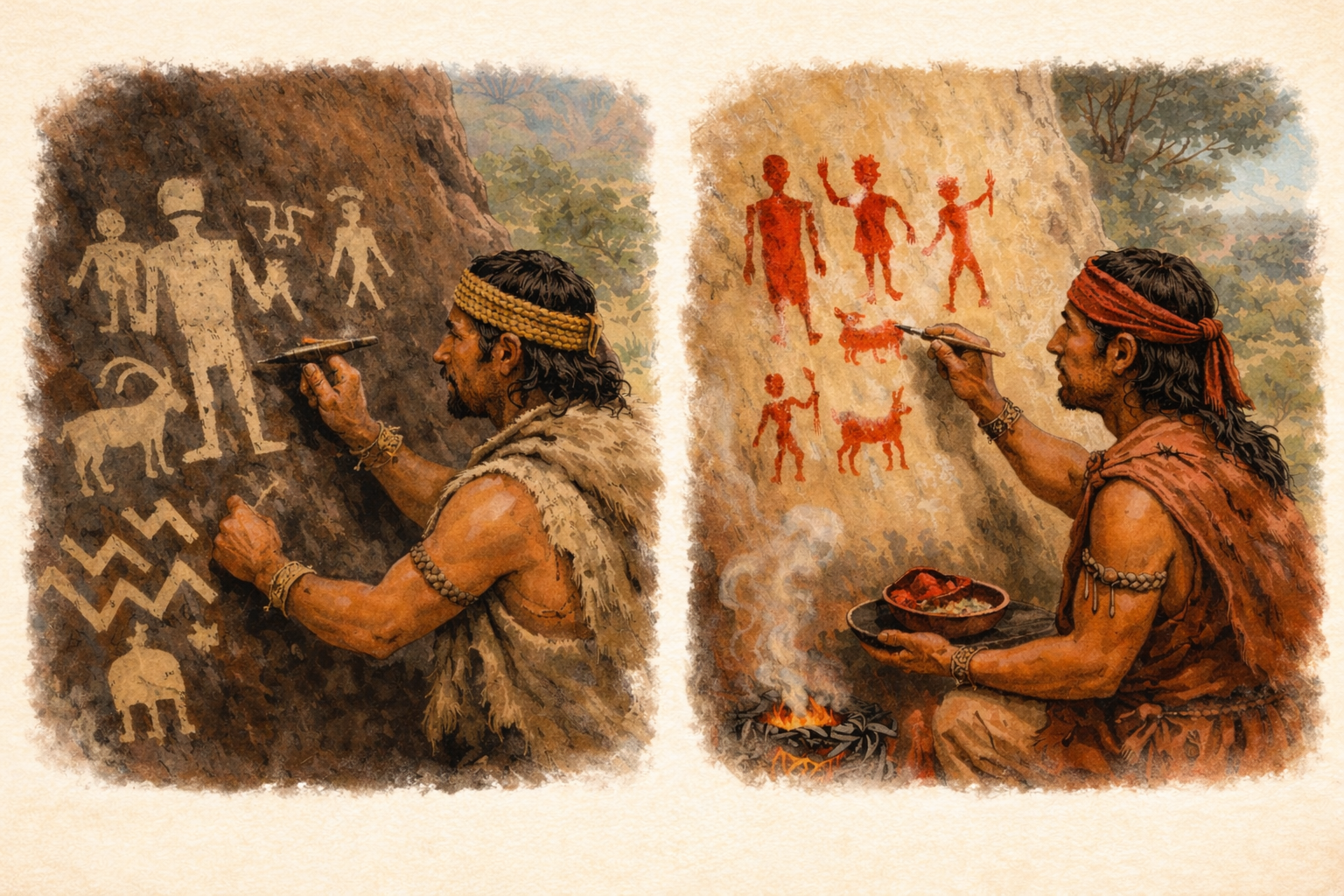
Illustrated comparison of petroglyphs and pictographs, showing the difference between carved rock art (petroglyphs) and painted rock art (pictographs) in the American Southwest.
There are two main types of ancient rock art found throughout the Southwest: petroglyphs and pictographs. While people often use the words interchangeably, they are created in very different ways.
Petroglyphs are images carved or pecked directly into rock. The figures you see etched into sandstone walls around Moab were created by removing the darker outer layer of desert varnish to reveal the lighter stone beneath.
Pictographs, on the other hand, are painted onto rock surfaces using natural pigments made from minerals, charcoal, and plant material.
Around Moab, most of what you’ll see are petroglyphs — carved, not painted — though pictographs exist in other parts of the Southwest.
Who Created the Petroglyphs Near Moab?
The rock art around Moab was created by different cultural groups over long stretches of time — which is why the styles vary.
Some of the oldest imagery in the broader region, often referred to as Barrier Canyon Style, may date back thousands of years to the Archaic period. These figures tend to be more abstract, elongated, and sometimes lack detailed facial features.
Later, the Fremont culture (approximately 300–1300 A.D.) created many of the petroglyphs seen around Moab today. Fremont figures are often anthropomorphic with large eyes, detailed adornment, and distinct body shapes.
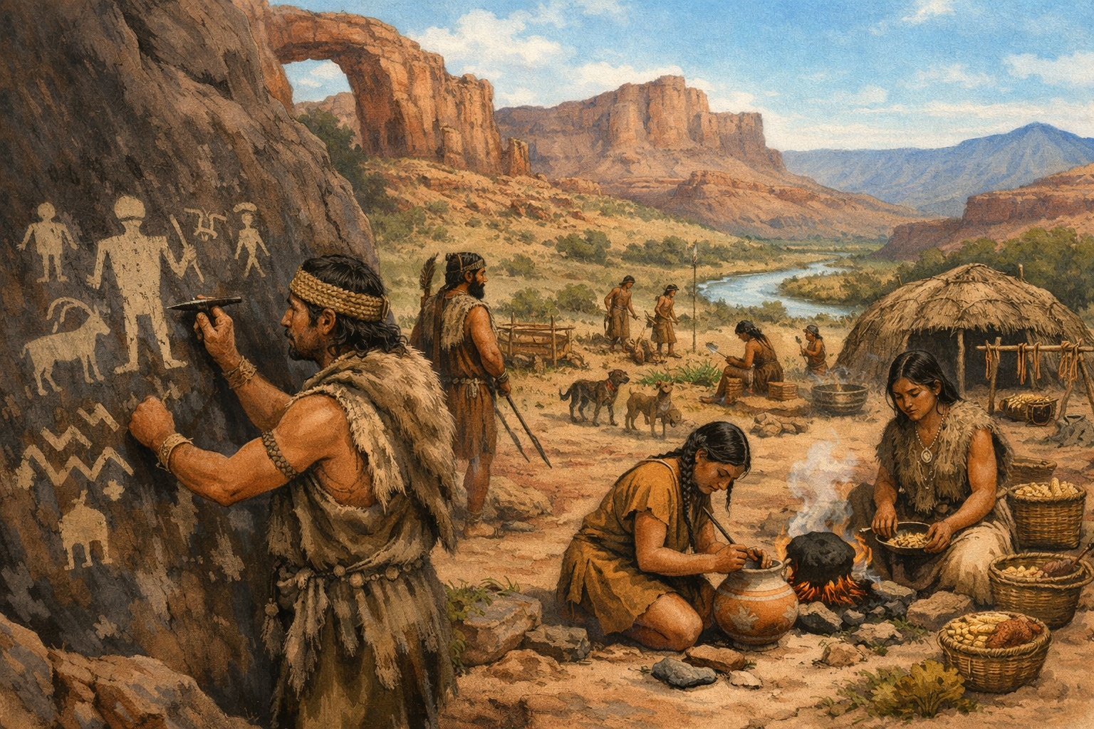
Illustrated interpretation of Fremont-era life along the Colorado River corridor near present-day Moab, depicting the creation of petroglyphs within a desert settlement landscape.
After the Fremont period, Ute and Diné (Navajo) peoples also left their marks on the landscape. Their imagery can include horses, riders, and symbols that reflect later historical periods.
So yes — differences in style are often tied to when the images were created and which cultural group made them.
It’s important to understand that these carvings are not decorative art in the modern sense. While we can’t know the exact intention behind every figure, archaeologists believe they may have marked territory, recorded events, reflected spiritual or ceremonial beliefs, mapped resources, or expressed cultural identity and storytelling traditions. They represent presence in the landscape — a way of saying, we were here.
While most rock art immediately around Moab consists of petroglyphs (carved images), pictographs — painted figures — can be seen in places like Sego Canyon and Horseshoe Canyon, where Barrier Canyon Style imagery survives on sheltered cliff faces.
Where to See Petroglyphs Near Moab
There are seven commonly referenced rock art sites in and around Moab. Some are visible from the road; others require a short walk.
Sego Canyon
Located northeast of Moab near Thompson Springs, Sego Canyon features multiple layers of rock art, including Archaic Barrier Canyon Style figures, Fremont petroglyphs, and historic-era inscriptions.
Why go:
Multiple time periods in one location
Both petroglyphs and pictographs
One of the most visually striking panels in the region
Coordinates (approx.): 39.1515° N, 109.6540° W
Type: Petroglyphs & Pictographs
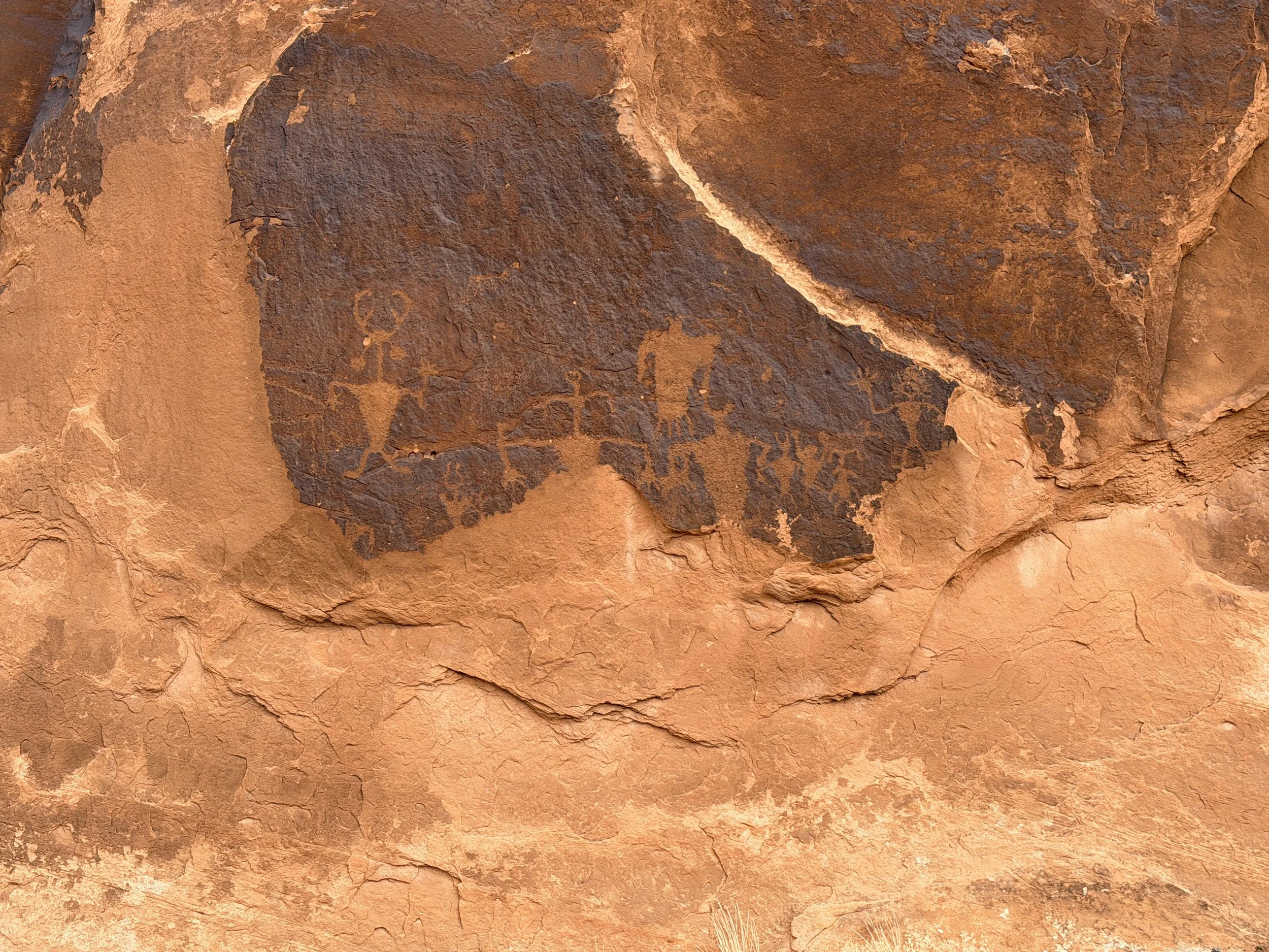
Birthing Scene Panel
You reach this panel by driving along the Colorado River corridor outside town. The road winds past campgrounds and trailheads for off‑road riding, hiking, and mountain biking. Eventually, the pavement turns to dirt. The panel — which is really a massive standalone boulder — sits on the right side of the road, protected by a small wooden fence. It’s just there in the open desert.
These are some of the clearest, best‑preserved petroglyphs I saw in Moab.
The site is commonly referred to as the "Birthing Scene" because one of the central anthropomorphic figures appears to show a smaller figure emerging from the lower body. Some researchers and visitors interpret this as a depiction of childbirth.
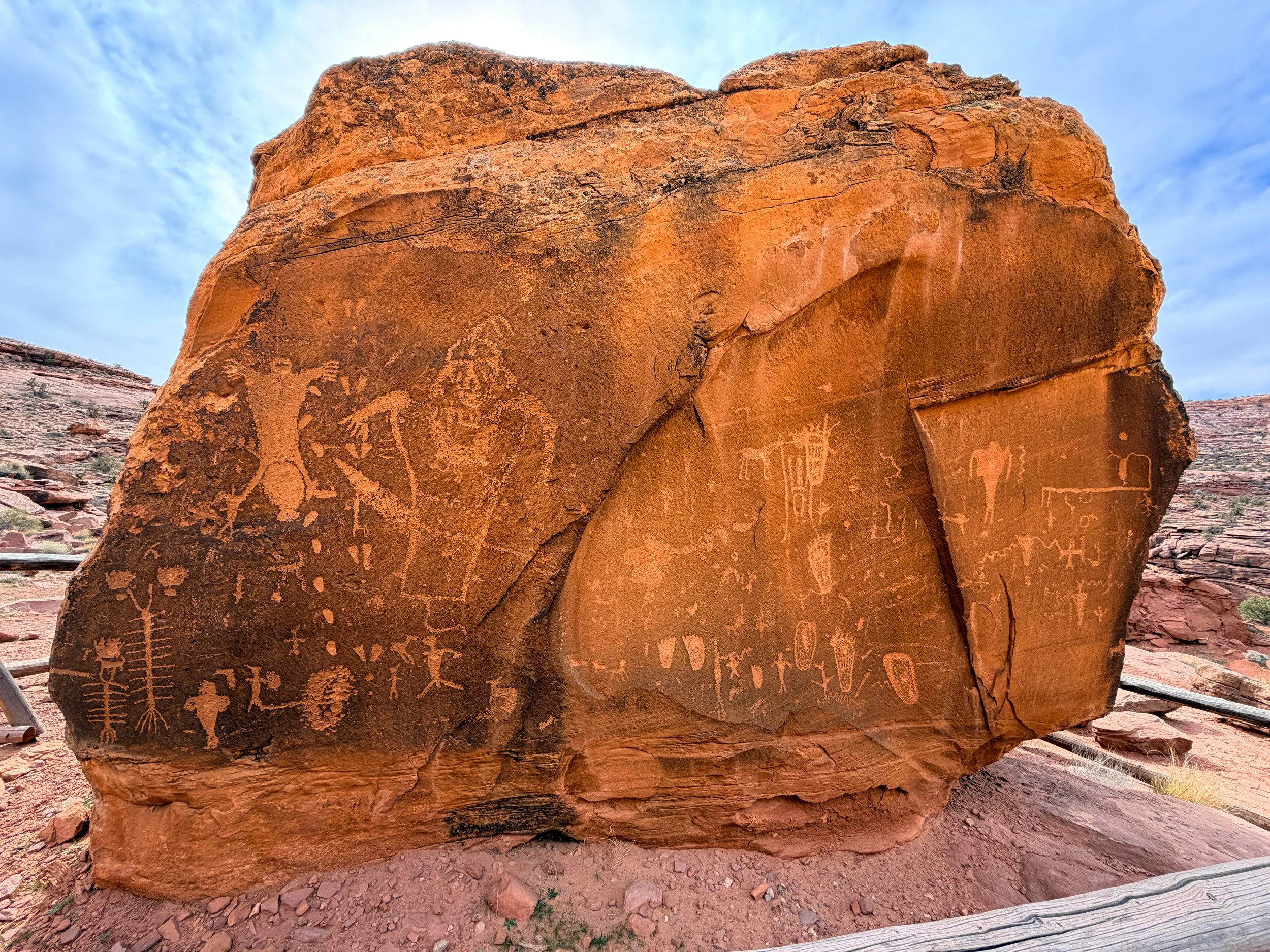
The Birthing Scene Panel — a massive, standalone boulder covered in deeply pecked Fremont petroglyphs beside the Colorado River corridor.
That interpretation is not universally agreed upon. Rock art meaning is often speculative, and without written records from the Fremont culture (300–1300 A.D.), we rely on stylistic analysis and comparison with other panels. The name "Birthing Scene" is modern — a descriptive label based on how contemporary viewers read the imagery. Interpretations of rock art often reflect modern cultural assumptions, and without direct records from the people who created it, meaning remains informed but uncertain.
What makes this panel significant is not just the possible interpretation but the clarity of the carving. The figures are deeply pecked through desert varnish, creating sa trong contrast that has endured for centuries.
This panel is generally attributed to the Fremont culture (300–1300 A.D.), though interpretations of the imagery vary.
It’s one of the strongest panels I’ve seen in the area. The scale, the clarity of the carving, and the setting make it feel immediate rather than distant.
What you’ll see:
A large anthropomorphic figure with a distinctive body shape
Smaller accompanying figures and symbols
Deeply pecked lines carved through desert varnish
Why go:
Frequently photographed
Distinctive and widely discussed imagery
Type: Petroglyph
Coordinates (approx.): 38.5738° N, 109.5552° W
Courthouse Wash
Near the entrance to Arches National Park, this panel is accessible via a short walk and contains large Fremont-style anthropomorphic figures.
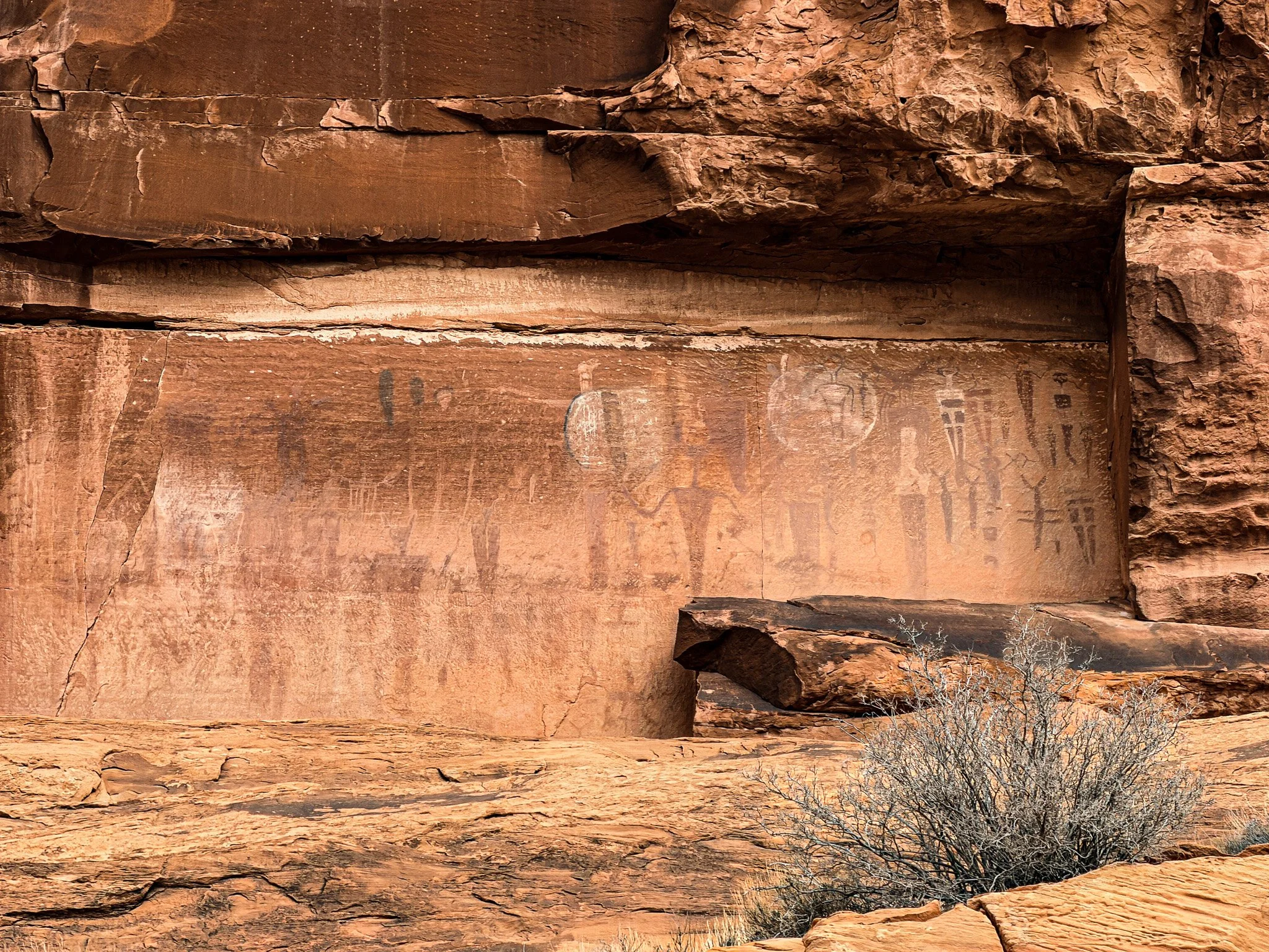
Courthouse Wash petroglyph panel near the entrance to Arches National Park — large Fremont figures etched into a vertical sandstone wall.
Why go:
Close to town
Prominent and easily visible figures
Coordinates (approx.): 38.6008° N, 109.5460° W
Type: Petroglyphs
Golf Course Rock Art Site
Near the Moab Golf Course, this lesser-known panel includes Fremont-style figures and symbols carved into sandstone. This site sits among homes, townhomes, and yes, next to a golf course. As soon as you see the rock wall with a parking area in front, you know you are there. This one is not as grand as some. But, I found this one fun to try to find them all. Kind of like a scavenger hunt of petroglyphs. Over time, the black has worn down; therefore, parts have been removed, or not all of them.
Fremont-style petroglyphs at the Moab Golf Course site — carved into desert varnish along a sandstone wall just outside town.
Why go:
Often quieter than major sites
Easy access from the town
Type: Petroglyphs
Coordinates (approx.): 38.5315° N, 109.5035° W
Kane Creek Boulevard Area
Along Kane Creek Boulevard, several panels are visible from the road and nearby trails.
Why go:
Close to town
Pairs well with scenic drives or rides
Coordinates (approx.): 38.5550° N, 109.5850° W
Type: Petroglyphs
Wolfe Ranch (Delicate Arch Area)
Located near the historic Wolfe Ranch cabin along the Delicate Arch trail inside Arches National Park, this panel features later-period Ute petroglyphs carved into a low sandstone wall.
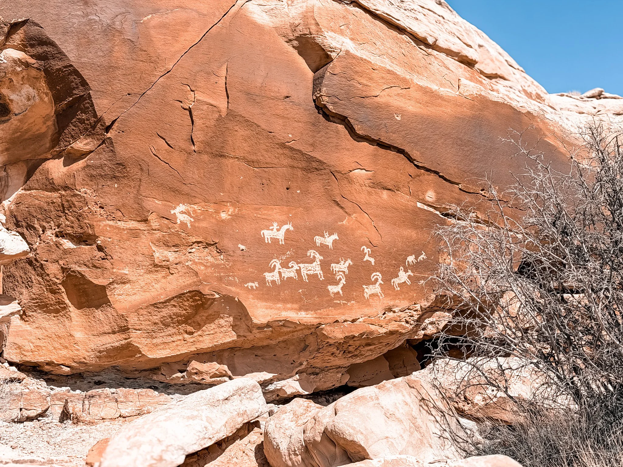
Ute petroglyph panel near Wolfe Ranch along the Delicate Arch trail in Arches National Park, featuring animal figures carved into sandstone.
These figures are not as old as some Fremont panels in the region, which is part of why they appear more vivid and easier to distinguish. The lighter contrast against the sandstone makes the animal forms especially clear.
If you’re hiking to Delicate Arch, this is an easy addition. The panel sits just off the main trail shortly after leaving the parking lot, making it one of the most accessible cultural sites inside the park.
Why go:
Combines a major Arches hike with cultural history
Clear animal figures visible from the trail
Located right along the Delicate Arch route
Type: Petroglyphs
Coordinates (approx.): 38.7436° N, 109.4993° W
Potash Road Panels
Along Potash Road (UT‑279), which runs along the Colorado River west of town, several additional petroglyph panels are visible from roadside pullouts. These are located across the river corridor from the Birthing Scene panel.
Most of the imagery here is Fremont‑style, carved through dark desert varnish into vertical sandstone walls lining the river canyon.
Why go:
Multiple pullouts with visible panels
Scenic river backdrop
Coordinates (approx.): 38.5730° N, 109.5515° W
Type: Petroglyphs
How to View Rock Art Respectfully
Petroglyphs survive because of the desert’s dry climate. Oils from skin, friction, and climbing accelerate erosion on surfaces that have already endured for centuries.
At nearly every site I visited, I saw some form of vandalism — names scratched into stone, initials carved beside ancient figures, modern marks layered over centuries‑old imagery. It’s hard to understand. These are cultural records. They’re history. They’re works of human expression that have survived this long only because the desert protected them.
Once damaged, they cannot be restored to their original state.
When visiting:
Do not touch the rock art
Do not trace figures
Do not climb on panels
Stay on established paths
Avoid chalk or marking the rock
Look. Photograph. Don’t touch.
These sites are protected cultural resources. Treat them as living history — not as blank space for your own mark.
What It Feels Like Standing There
The same cliffs that hold climbing routes and bike trails also hold cultural memory.
When you hike, ride, or drive through these corridors, you are moving through a layered landscape shaped by human presence long before recreation.
Understanding that changes how the place feels — Moab is not just scenery; it is history in plain sight.
More in the Moab Series
This article is part of an ongoing Moab series exploring the landscape from multiple angles — history, geology, riding, and national parks.
The Moab You Didn’t Know About: Dinosaurs, Petroglyphs & the Desert Before the Bikes
Dinosaurs Near Moab: Track Sites, Fossils & Where to See Them
Moab’s Uranium Boom: How the Atomic Age Reshaped the Desert Town
Potash Ponds Near Moab: What Those Bright Blue Pools Really Are
Michele Underwood writes Overland Girl, where she shares firsthand travel experiences across the American West — from desert landscapes and national parks to small towns layered with history. Her work blends movement, place, and the stories that shape them.

Some posts may include affiliate links to products or services she uses on the road. If you choose to purchase through those links, she may earn a small commission at no additional cost to you. It helps support continued travel and storytelling. She only links to items she personally uses or would use herself.