
Moab’s Uranium Boom: How the Atomic Age Reshaped a Desert Town
The Cold War chapter that transformed Moab — and what’s still visible today.
Words by Michele Underwood | Photos by others

Main Street in Moab during the uranium boom, lined with motels, gas stations, and neon signage as traffic increased through town. Credit: National Archives, U.S. Government Work, Public Domain.
Before the Trails, There Was Uranium
Moab feels like an outdoor town now. Mountain bikes on racks. Jeeps rolling through town. River guides loading rafts at dawn.
But in the 1950s, this place ran on something else entirely.
Uranium.
During the early years of the Cold War, the U.S. government offered financial incentives for uranium discovery. Prospectors flooded the Colorado Plateau searching for ore that could be used in nuclear weapons and atomic energy development. The federal government guaranteed high prices for uranium, turning remote desert canyons into opportunity.
Moab became the center of it.
The Boom Years
In 1952, geologist Charles Steen struck a major uranium deposit near Moab. The discovery triggered a rush.
Miners staked claims across canyon country. Processing facilities were built. The population surged. Hotels filled. New businesses opened. Trucks hauling ore became part of the daily landscape.
What had been a small agricultural and ranching community rapidly transformed into a mining boomtown.
The town’s identity shifted almost overnight.
You can still feel that energy in the stories told at the Moab Museum. Photos from the era show optimism, risk, and the sense that something big was happening out here in the desert.
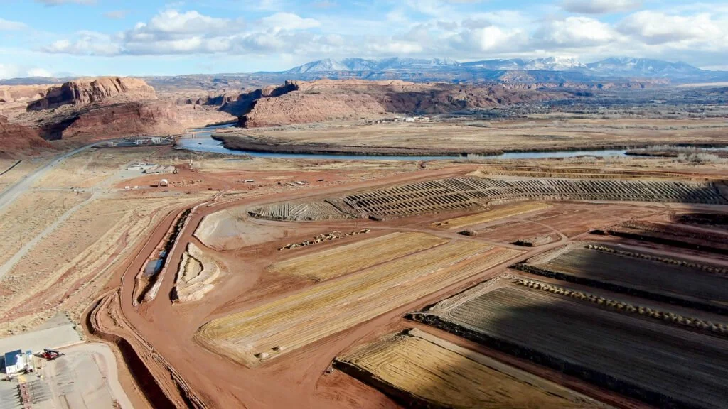
The Mill and the River
A uranium processing mill operated along the Colorado River just outside town. Ore from surrounding mines was brought in, crushed, and chemically processed to extract uranium.
The leftover material — known as mill tailings — remained on site for decades.
When uranium prices collapsed in the 1960s and federal incentives ended, the boom faded. Mines closed. Jobs disappeared. Moab faced an economic downturn that forced reinvention.
But the physical legacy remained.
Today, a long-term federal cleanup project continues to remove and relocate contaminated tailings from the former mill site. Truckloads of material have been transported north to a disposal site near Crescent Junction. It’s one of the largest environmental remediation efforts in the region.
The red rock didn’t change. The economy did.
Reinvention: From Extraction to Recreation
When mining declined, Moab had to pivot.
What replaced uranium wasn’t agriculture.
It was a landscape.
The same cliffs that once framed mining claims became climbing routes. Slickrock that prospectors drove across became legendary mountain bike terrain. The Colorado River shifted from industrial corridor to recreational artery.
Arches National Monument had already been established in 1929, but by the 1970s — redesignated as a National Park — recreation began reshaping the town’s identity.
Moab reinvented itself.
What You Can Still See Today
If you slow down, traces of the uranium era remain:
Mining roads spiderwebbing into remote canyons
Historic claim markers
Museum exhibits documenting the boom years. Right now, the Moab Museum has an excellent exhibit on this. This is where I learned about uranium mining in Moab.
Ongoing cleanup efforts along the river corridor
It’s easy to come here for the trails and never think about this chapter.
But the modern Moab economy exists partly because the mining economy collapsed.
That tension — extraction and recreation — is part of the town’s layered identity.
Why This Layer Matters
Understanding the uranium boom changes how Moab feels.
It reminds you that this isn’t just a playground carved out of the empty desert. It’s a town that has cycled through ambition, risk, collapse, and reinvention. This city powered the testing site in Nevada that poured so much backwash into so many communities for miles.
The cliffs held dinosaurs. The walls hold petroglyphs. The canyons held uranium.
It’s all part of the same landscape.
Pro tip: Charles Sheen’s house, which sits atop a cliff, is now a restaurant where you can watch the sunset.
More in the Moab Series
This article is part of an ongoing Moab series exploring the landscape from multiple angles — history, geology, riding, and national parks.
The Moab You Didn’t Know About: Dinosaurs, Petroglyphs & the Desert Before the Bikes
Dinosaurs Near Moab: Track Sites, Fossils & Where to See Them
Petroglyphs Near Moab: Where to See Rock Art & What It Means
Potash Ponds Near Moab: What Those Bright Blue Pools Really Are
Michele Underwood writes Overland Girl, where she shares firsthand travel experiences across the American West — from desert landscapes and national parks to small towns layered with history. Her work blends movement, place, and the stories that shape them.Some posts may include affiliate links to products or services she uses on the road. If you choose to purchase through those links, she may earn a small commission at no additional cost to you. It helps support continued travel and storytelling. She only links to items she personally uses or would use herself.