
Potash Ponds Near Moab: What Those Bright Blue Pools Really Are
The industrial geometry you see when driving along the Colorado River.
Words by Michele Underwood | Photos by an astronaut & Karsten Winegeart
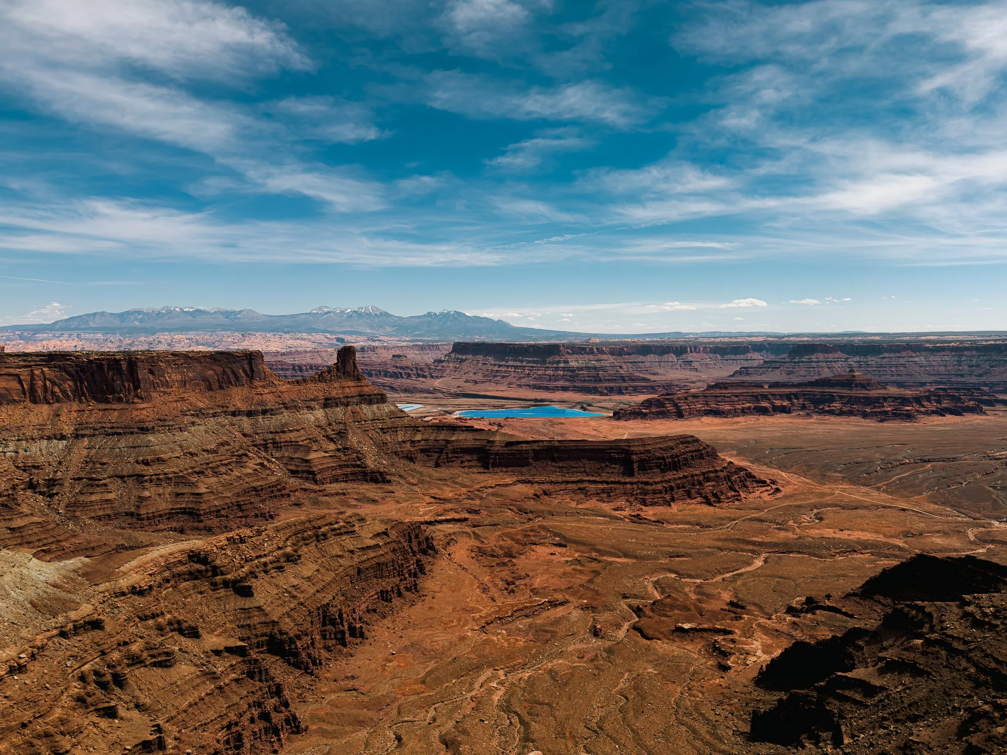
Looking out over the Colorado River basin from Dead Horse Point State Park, with the potash evaporation ponds visible in the distance.
You’re driving along the Colorado River on Potash Road (UT-279). The pavement eventually gives way to a rougher road. Cliffs rise straight up on one side. The river runs steadily on the other.
Then you notice what looks like a strange lake off to the side — fenced off from the road.
It doesn’t immediately register as industrial. It just looks… contained. Flat. Still.
You drive a little farther and see more of them — smaller ponds stepping back into the desert floor.
The first time I saw them, they weren’t glowing blue at all. They were dark. Brown. Almost murky.
If you’ve seen the aerial photos online, you expect neon turquoise. Electric color against red rock.
But on the ground, it can look muted. Industrial. Quiet.
And then you realize what you’re looking at.
They’re potash evaporation ponds.
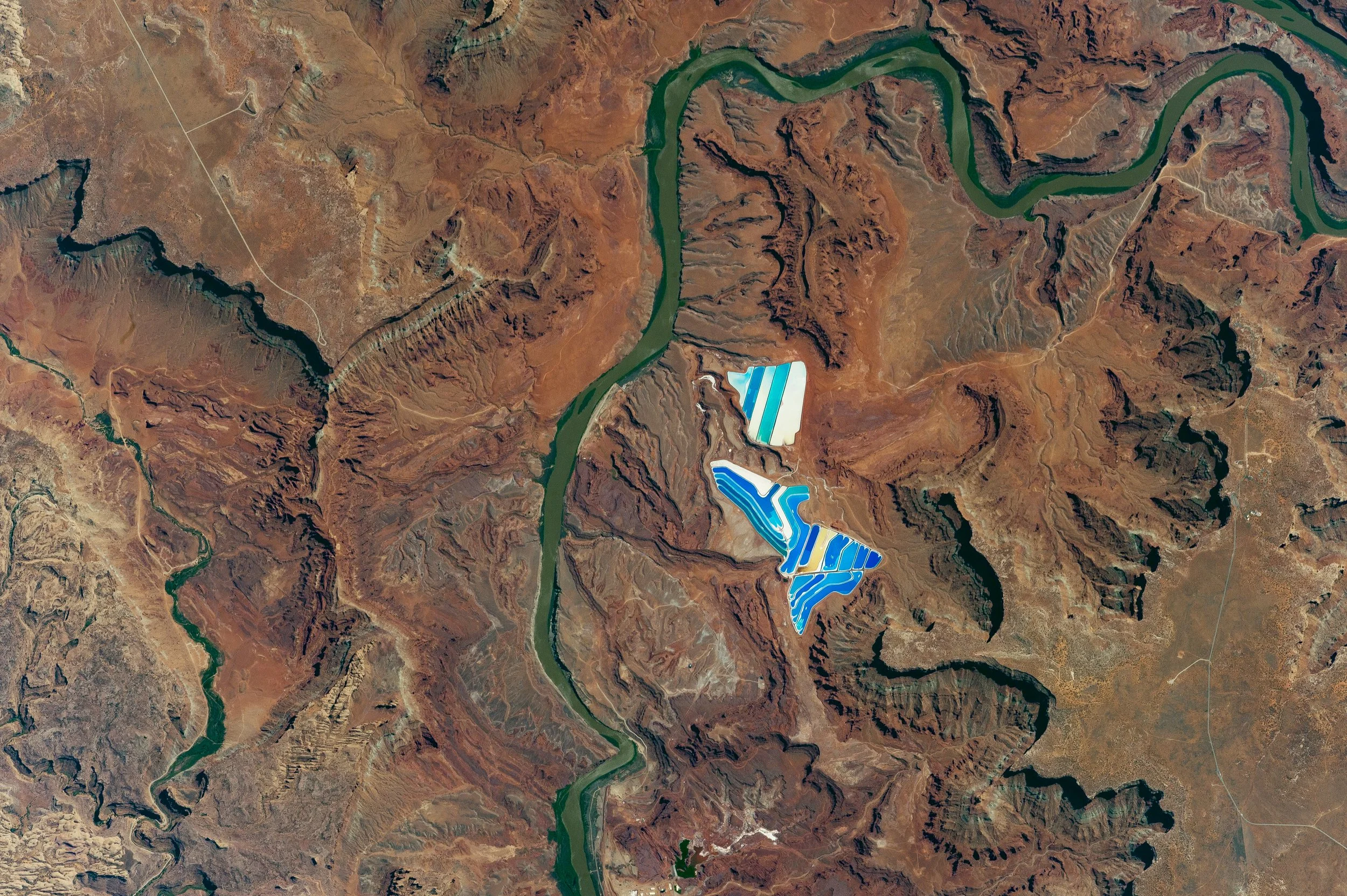
Satellite view of the Colorado River winding through canyon country near Moab, with blue and white potash evaporation ponds visible against red rock desert.
What Is Potash?
Potash refers to potassium-bearing minerals used primarily in fertilizer production.
Potassium is one of the three essential nutrients crops need, along with nitrogen and phosphorus. It helps regulate plant growth and improves yield.
The Moab area sits above ancient evaporite deposits — minerals left behind when inland seas dried up millions of years ago. Those buried salt layers are part of the Paradox Basin, which underlies much of this region.
That’s what’s being extracted here.
Brine is pumped from underground, channeled into large surface ponds, and left to evaporate under the desert sun. As the water evaporates, minerals concentrate and are later processed.
Why Are the Ponds Blue?
The blue color comes from mineral concentration and light reflection.
As brine evaporates, the chemistry changes. Different concentrations of salts reflect light differently. The depth of the water and angle of the sun also affect how it appears.
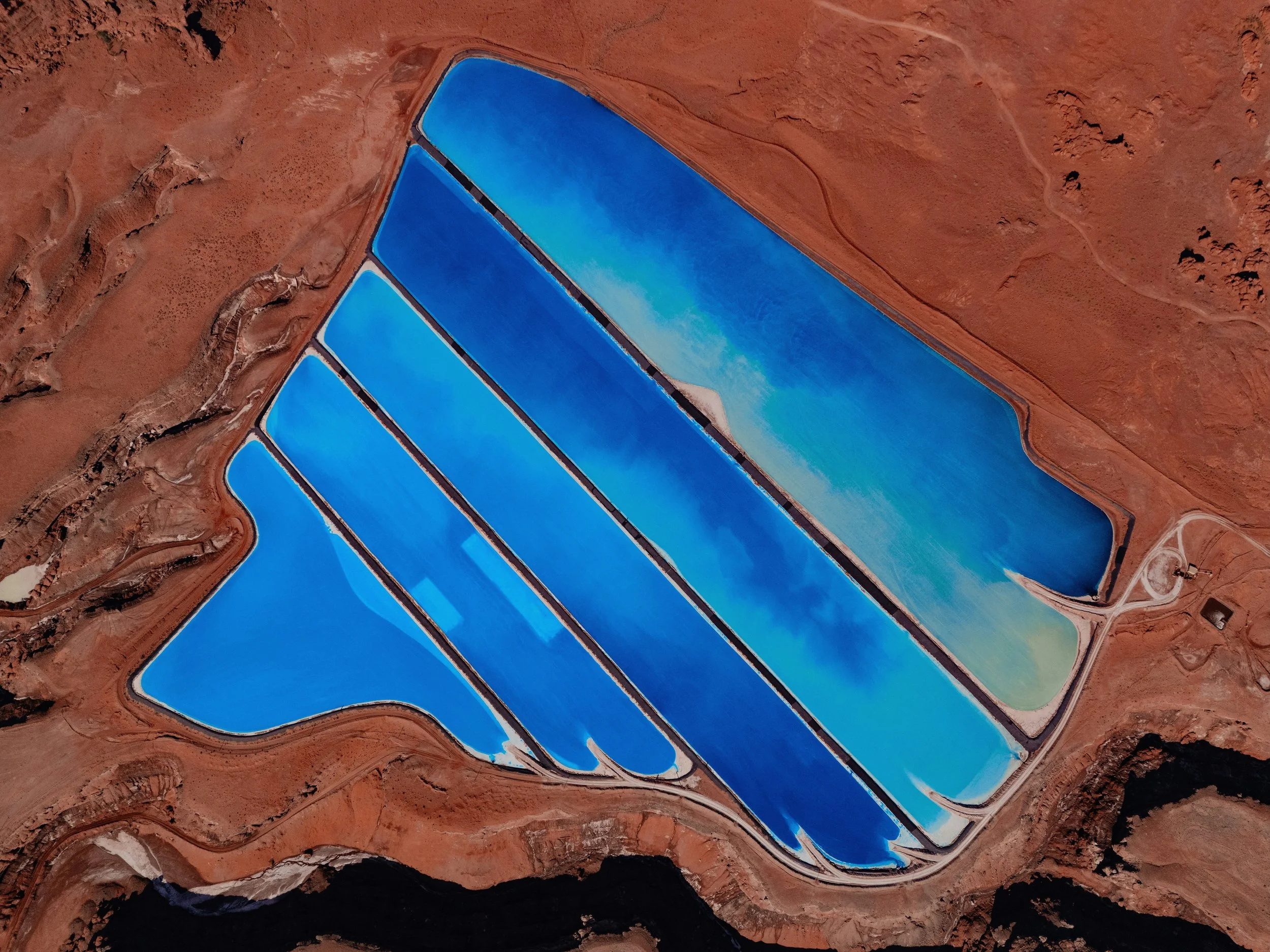
Evaporation ponds near Moab, Utah, showing vibrant blue mineral ponds against red desert earth. Photo by Karsten Winegeart / Unsplash.
Sometimes the ponds are bright turquoise.
Sometimes deep electric blue.
Sometimes teal.
And sometimes not blue at all.
The dramatic drone shots you see online are often taken when conditions are just right. On other days, the ponds can look subdued and brown.
It shifts with stage, season, and light.
Can You Visit the Potash Ponds?

Closer view of the potash evaporation ponds near Moab, set against the canyon layers and La Sal Mountains in the distance.
The site itself is an active industrial operation and fenced off. Access beyond public viewpoints is restricted.
You’ll likely see other cars and vans heading that direction. If not, you might start wondering where you’re going—it feels remote and a little off-road. There are plenty of “No Trespassing” signs along the road, too.
There’s no trailhead. No signage. Just a working facility.
And the signs make it clear you’re meant to observe from a distance.
You can see the ponds from Potash Road (UT-279) west of Moab.
As you drive along the Colorado River, you’ll pass pull-offs where you can safely stop and look across at the evaporation ponds. They’re easy to spot once you know what you’re looking at.
You can also see them from above at Dead Horse Point State Park, where the contrast between the red rock canyon and the bright blue ponds is more noticeable.
Coordinates (main viewing area, approximate): 38.5735° N, 109.6410° W
How It Fits Into Moab’s Story
If you’ve been following this Moab series, you know this place didn’t start as a recreation town.
Uranium shaped the Atomic Age here.
The Moab Fault shaped the landscape.
Dinosaurs walked through what is now the desert.
Petroglyphs mark human presence long before pavement.
Potash is part of that same story.
Moab didn’t flip from extraction to recreation overnight. Industry is still here. It just sits alongside the trailheads now.
You can ride in the morning.
You can drive past active mineral ponds in the afternoon.
More in the Moab Series
This article is part of an ongoing Moab series exploring the landscape from multiple angles — history, geology, riding, and national parks.
The Moab You Didn’t Know About: Dinosaurs, Petroglyphs & the Desert Before the Bikes
Dinosaurs Near Moab: Track Sites, Fossils & Where to See Them
Petroglyphs Near Moab: Where to See Rock Art & What It Means
Moab’s Uranium Boom: How the Atomic Age Reshaped the Desert Town
Michele Underwood writes Overland Girl, where she shares firsthand travel experiences across the American West — from desert landscapes and national parks to small towns layered with history. Her work blends movement, place, and the stories that shape them.Some posts may include affiliate links to products or services she uses on the road. If you choose to purchase through those links, she may earn a small commission at no additional cost to you. It helps support continued travel and storytelling. She only links to items she personally uses or would use herself.