
Hole-in-the-Rock Road in Grand Staircase–Escalante: The Story Behind the Road and What It Leads To
The road that opens up some of the most remote parts of southern Utah — and the story behind how it got there.
Words by Michele Underwood | Photos by Michele
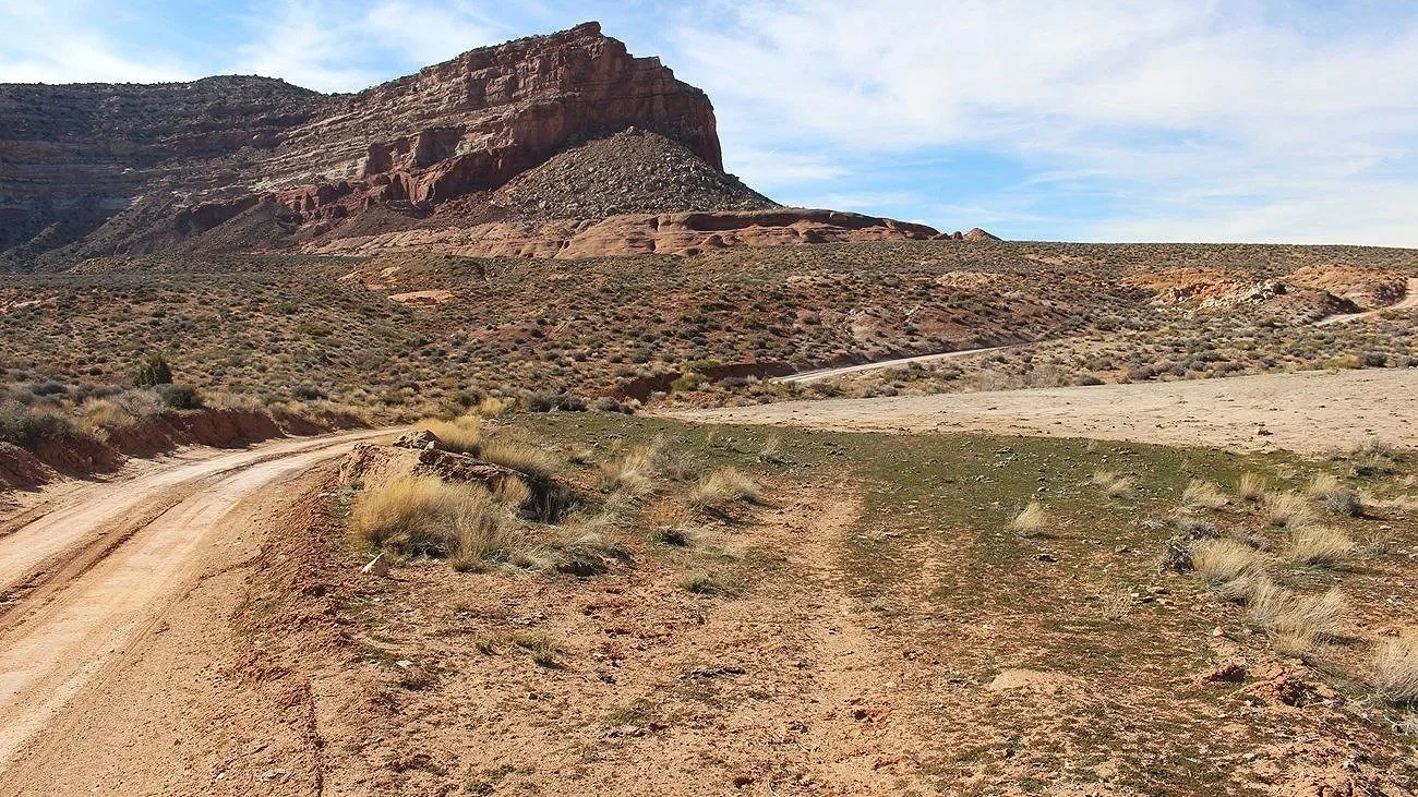
Hole-in-the-Rock Road crossing the desert in Grand Staircase–Escalante
Driving down Hole-in-the-Rock Road, you start to wonder if it’s really worth it. It’s long and rough, with miles of washboard, dust, and open desert that feel like they just keep going with no clear end in sight, but this road isn’t random and it’s not just there to get you to trailheads — there’s a reason it exists.
The road is rough enough that I ended up upgrading the shocks on my van instead of sticking with the stock setup.
This is also what Grand Staircase–Escalante National Monument is about. There are no paved roads leading you into it like other national parks. You have to drive into it, and that changes how you experience the place.
If you’re heading to places like Peek-a-Boo, Spooky, or Devil’s Garden, this is the road you’ll take.
What Hole-in-the-Rock Road Is
Hole-in-the-Rock Road is a dirt road that runs south from Scenic Byway 12 into Grand Staircase–Escalante National Monument.
It stretches for roughly 60 miles, cutting through open desert, sandstone formations, and some of the most remote terrain in southern Utah.
Today, it’s the main access point for places like Peek-a-Boo and Spooky Slot Canyons, Devil’s Garden, and the Dry Fork area, along with a number of lesser-known hikes and dispersed camping areas along the way.
If you’re exploring this part of Utah, chances are you’ll end up on this road at some point.
What It Used to Be
Hole-in-the-Rock Road wasn’t built for recreation or access to trailheads. It was created out of necessity.
In 1879, a group of Mormon pioneers — later known as the San Juan Expedition — set out to find a route to the Colorado River so they could establish a settlement on the other side.
What stood in their way was a stretch of rugged, unforgiving terrain with no obvious path through it.
When they came across a narrow break in the cliffs — what is now known as the Hole-in-the-Rock — they decided to make it work.
Over several months, they carved a passage through solid sandstone with hand tools, lowering wagons, supplies, and livestock down the rock face to create a route to the river.
It wasn’t a road in the way we think of one today. It was a solution to a problem, built by hand through terrain that didn’t want to be crossed.
What It Is Today
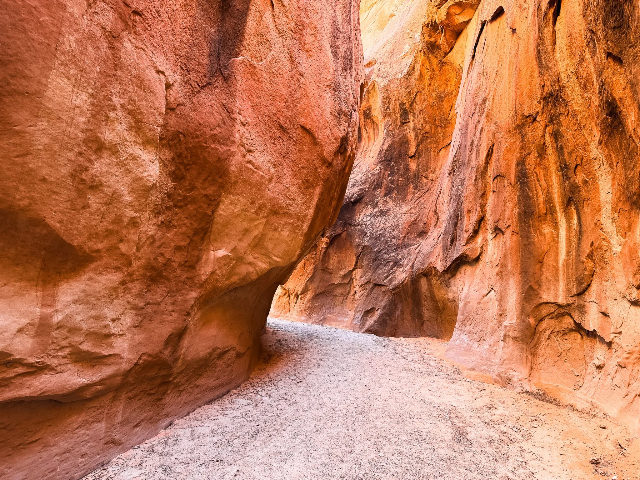
Dry Fork wash leading toward Peek-a-Boo in Grand Staircase–Escalante National Monument
Today, Hole-in-the-Rock Road is the main way into this part of Grand Staircase–Escalante National Monument.
It’s still rough and unpaved, but now it connects people to some of the most unique places in the area — slot canyons like Peek-a-Boo and Spooky, areas like Devil’s Garden, and trailheads that lead deeper into the monument.
Driving it now, you feel the distance more than the difficulty. The washboard, the length of the road, and the open landscape give it a sense of remoteness, even though it’s widely used.
It’s no longer about survival or building a route. It’s about access.
But knowing what it took to create it changes how the drive feels. It’s not just a road you happen to be on — it’s part of how people first moved through this landscape.
What It’s Like to Drive It
The first thing you notice is the washboard.
It’s constant, and while there are short stretches that smooth out, most of the drive is a steady vibration that makes you slow down and stay focused.
It doesn’t feel technical, but it feels long.
Once you’re on it, there’s no quick return to pavement. You’re committed to it, and that adds to the sense of being out there.
Conditions can also change quickly after rain, and sections of the road can become impassable, so checking conditions before heading out is worth doing.
What You Can Access From It
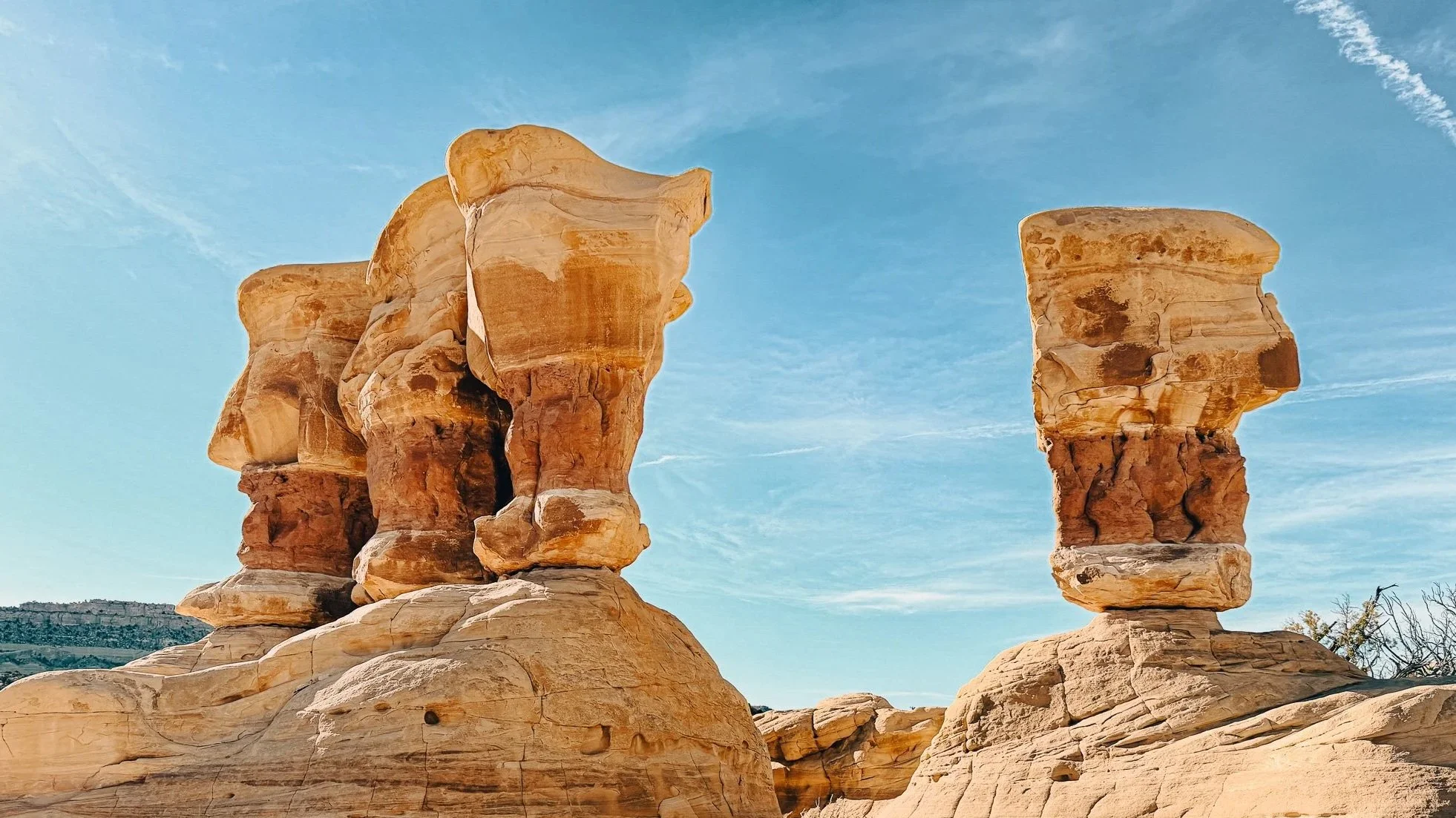
Hoodoo formations at Devil’s Garden in Grand Staircase–Escalante National Monument
Hole-in-the-Rock Road is what makes this part of the monument accessible.
From this one road, you can reach:
Peek-a-Boo and Spooky Slot Canyons: Read our story, Peek-a-Boo and Spooky Slot Canyons in Grand Staircase–Escalante National Monument
Devil’s Garden: Read our story, Devil’s Garden in Grand Staircase–Escalante National Monument
Dry Fork Narrows
There are also a number of lesser-known hikes, side canyons, and dispersed camping areas along the way, making it easy to spend multiple days exploring without retracing your steps.
Further down the road, access becomes more remote, with fewer people and longer distances between stops.
Reflection Canyon
Reflection Canyon is one of the more well-known destinations accessed from Hole-in-the-Rock Road, but it’s not something you just drive up to.
The trail starts off Hole-in-the-Rock Road, and from there it’s a long hike out to the overlook. The road itself continues past this trail access and eventually ends at the Hole-in-the-Rock trailhead.
What makes Reflection Canyon stand out is the view — a dramatic S-shaped bend along Lake Powell, surrounded by Navajo sandstone cliffs. It’s one of those places you see in photos and immediately recognize.
It’s a bigger commitment than stops like Peek-a-Boo, Spooky, or Devil’s Garden, but it’s also one of the highlights of the entire area.
It’s a hike I’d like to come back and do.
The End of the Road
Hole-in-the-Rock Road does not connect through to another highway or continue into Arizona.
It ends.
At the very end is the Hole-in-the-Rock, a narrow, steep passage carved into the sandstone that leads down toward the Colorado River.
To reach the overlook, you’ll need to hike the final section from where the road stops.
From there, you’re looking down at a bend in the Colorado River, just upstream of Lake Powell, with wide, open views across the canyon.
It’s not a dramatic landmark in the way people might expect, but once you understand what it took to create that route, the place carries a different kind of weight.
What Happened After That
The Hole-in-the-Rock wasn’t the destination for the settlers — it was the hardest part of the journey.
They carved a route down to the river, lowered wagons and supplies through it, crossed the Colorado River, and continued on to establish the town of Bluff, Utah.
What’s left today isn’t a single landmark to look at. It’s the route itself and the scale of what they managed to do.
Camping Along the Road
There are multiple dispersed camping spots along Hole-in-the-Rock Road, especially near the beginning of the route.
I camped at Hole-in-the-Rock Road Dispersed Camping, which I found on The Dyrt. There are a ton of pull-offs where you can park and set up camp.
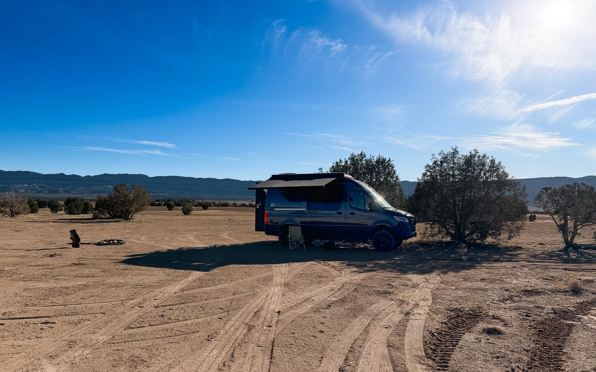
Dispersed camping off Hole-in-the-Rock Road in Grand Staircase–Escalante
Coordinates:
Hole-in-the-Rock Road Dispersed Camping
37.71879301 N, -111.52849155 WIt’s easy to find spots, and many of them are close enough to the main road that they don’t feel overly remote.
I stayed here for a few nights, and it worked well as a base for exploring the area.
Camping + Trail Apps I Use
Apps come in very handy when you go off-trail or into more remote areas, but for them to actually work out here, you usually need the Pro version to download maps and information ahead of time.
These are the ones I rely on.
The Dyrt Pro App
I use The Dyrt to find camping spots like this and check reviews from other campers before pulling in. It’s helpful for seeing what to expect and finding additional options nearby.
→ Download The Dyrt Pro before you go
Trailforks Pro App
→ I also use Trailforks to track where I am on trails and routes, especially in areas where things aren’t clearly marked. There’s no cell service in places like this, so downloading maps ahead of time is key. The Trailforks Pro version is worth it for offline access.
→ Download Trailforks before you go
Why It Stood Out
To get to some of the places I really wanted to see in Grand Staircase–Escalante National Monument, I had to take this road.
This road isn’t the destination, but without it, most places in this part of the monument would be difficult to reach.
Once you understand the history behind it, the entire experience changes.
Final Thoughts
Hole-in-the-Rock Road is one of those places that doesn’t stand out at first.
It’s just a long dirt road.
But the more time you spend on it, and the more you understand where it came from, the more it becomes part of the experience itself.
Explore More in Grand Staircase–Escalante
Grand Staircase–Escalante National Monument: My Favorite Hikes and Places to Explore
I Thought a National Monument Was Small — Then I Saw Escalante
Calf Creek Falls & Campground: One of the Best Stops I Made
Devil’s Garden in Grand Staircase–Escalante National Monument
Peek-a-Boo and Spooky Slot Canyons in Grand Staircase–Escalante National Monument
Michele Underwood writes Overland Girl, where she shares firsthand travel experiences across the American West — from desert landscapes and national parks to small towns layered with history. Her work blends movement, place, and the stories that shape them.

Some posts may include affiliate links to products or services she uses on the road. If you choose to purchase through those links, she may earn a small commission at no additional cost to you. It helps support continued travel and storytelling. She only links to items she personally uses or would use herself.