
Grand Staircase–Escalante National Monument: My Favorite Hikes and Places to Explore
A firsthand guide to hiking slot canyons, desert waterfalls, and exploring one of southern Utah’s most remote landscapes.
Words by Michele Underwood | Photos by Michele
Spending time around Grand Staircase–Escalante National Monument ended up being one of the highlights of my time in southern Utah. It wasn’t even on my agenda at first, but I was driving through the area on my way to Bryce Canyon National Park and then again after leaving Bryce. Both times, I found myself seeing more of the landscape.
The area feels massive and remote. If you look at it on a map, you realize just how huge it really is. Grand Staircase–Escalante covers nearly two million acres, making it one of the largest protected landscapes in the United States. In fact, it’s even larger than Canyonlands National Park, which is already enormous. Compared to nearby national parks, many of the places here require a little more effort to reach, but that’s part of what makes exploring the area so rewarding.
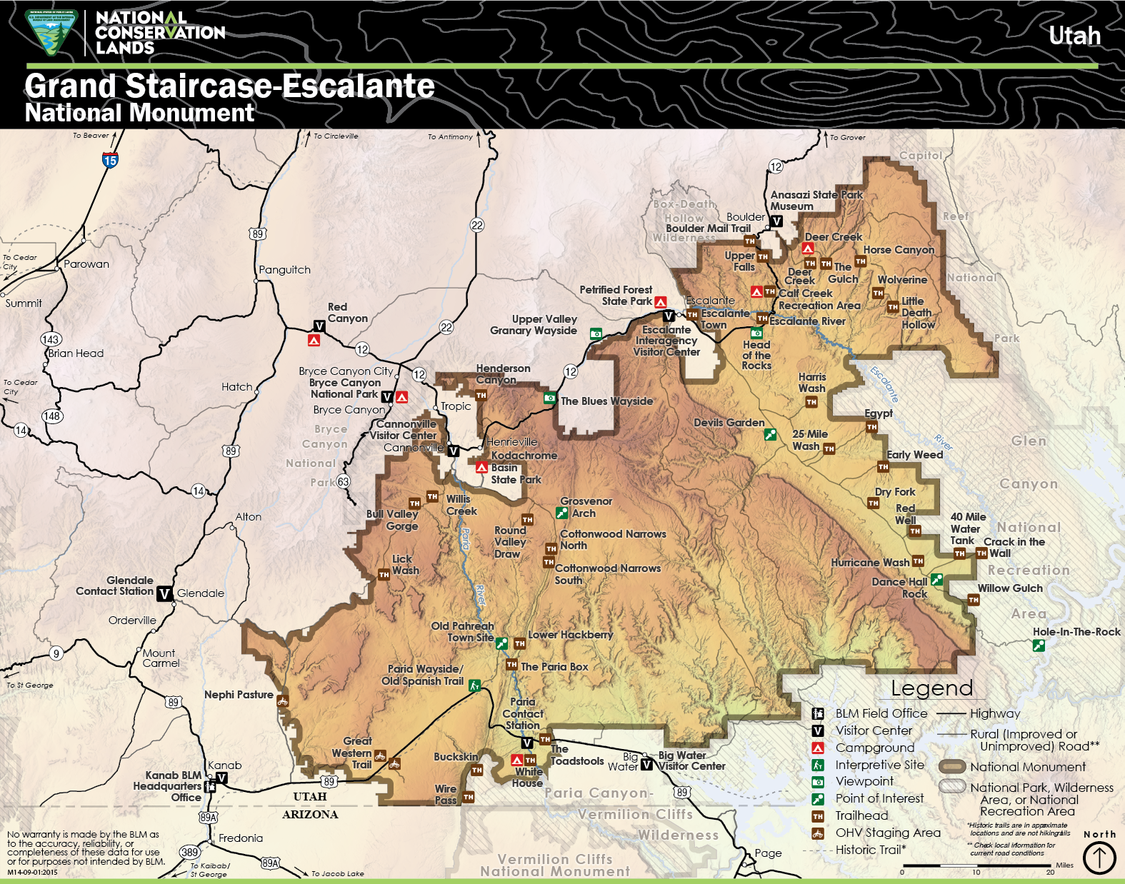
Map of Grand Staircase–Escalante National Monument showing the monument boundaries and surrounding towns in southern Utah.
Slot canyons twist through the desert rock, waterfalls appear in unexpected places, and strange sandstone formations rise from the landscape. Much of the area still feels wild and largely untouched. Most of the hikes and sites are reached by dirt roads rather than paved ones.
These are the places I explored and enjoyed while spending time around Escalante.
Exploring the Town of Escalante
The small town of Escalante sits along Utah State Route 12 and serves as one of the main gateways into Grand Staircase–Escalante National Monument.
It’s a quiet desert town, but it’s a great place to stop, grab food, and regroup between hikes and exploring the surrounding desert. After spending long days out in the canyons, coming back into town felt like a nice reset.
There are a few places in town that stood out to me:
Escalante Mercantile
The owner of this tiny grocery has done a great job with the selection of goods. You’ll find high-quality foods, including organic items similar to what you might see at stores like Sprouts or Whole Foods. Visit their Facebook page for more information.
Pro tip: The homemade hummus is amazing.
Escalanta Outfitters: This spot is amazing. Their restaurant serves up some of the best food I have had. I am talking Chicago quality food. I had a very delicious meatball sandwich that I would give 5 stars. Then, I tried their pizza another day, so good. another 5 stars. They have a small shop where you can pick up gear from brands like Patagonia, Prana, and more. Visit their website for more information.
Blue Crow Gear and Gifts: This shop is not only in a pink building, which is awesome, but also serves up the best coffee in town. And, they have a great gear shop. I purchased a number of Gregory items for the van and picked up a few more Snow Peak spoons, too. Visit their website for more information.
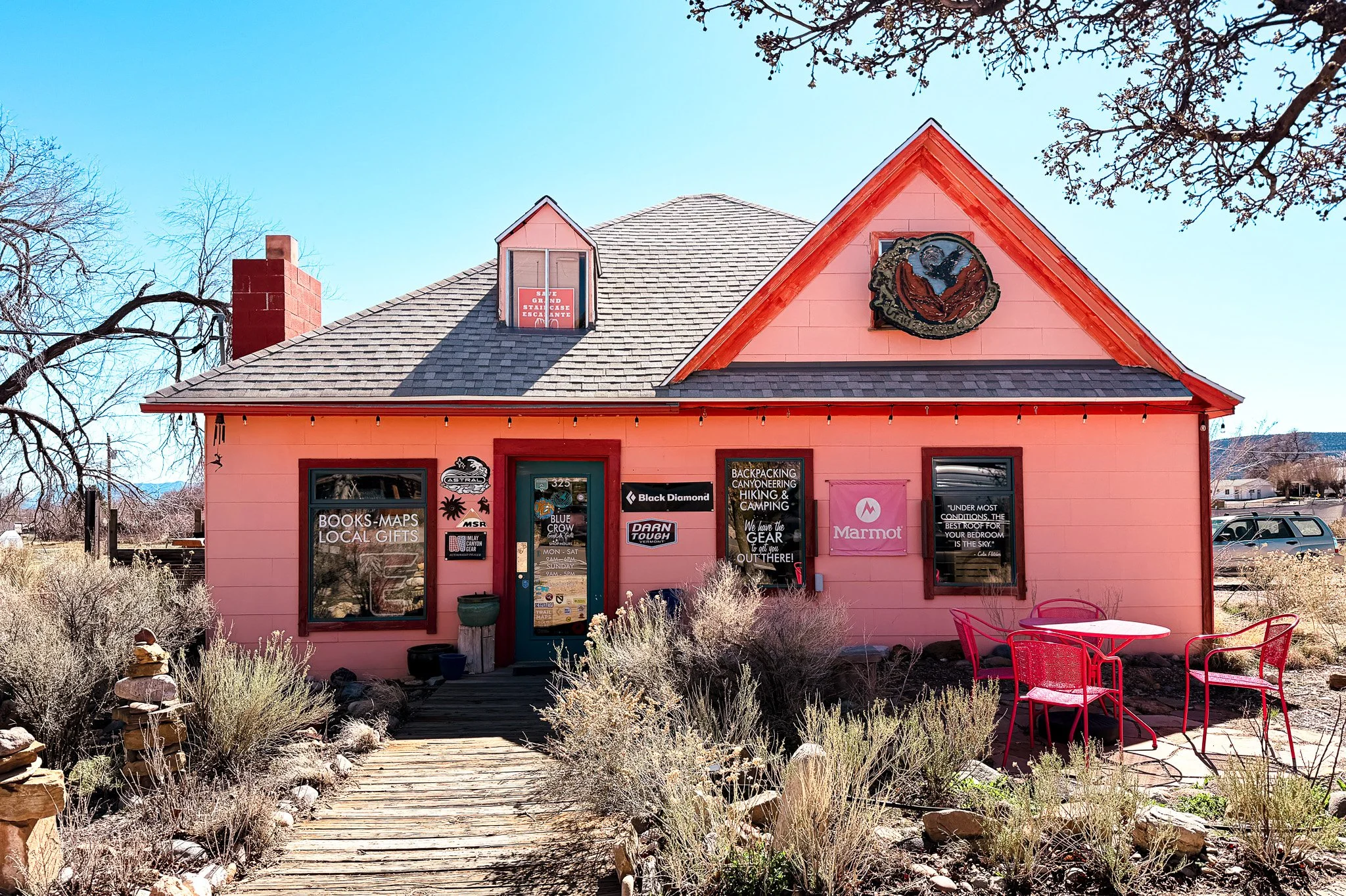
Blue Crow Gear & Coffee in Escalante, Utah — a small outdoor shop and coffee stop along Scenic Byway 12.
Escalante also has a few small museums and visitor information stops that help explain the region's geology and history. Spending a little time in town helps put the surrounding landscape into context.
Escalante Town: 37.7703, -111.6027
A Stop in Boulder, Utah
Just west of Escalante along Utah State Route 12 sits the small town of Boulder.
I stopped here on my way to Bryce Canyon National Park after passing through town and noticing the Anasazi State Park Museum.
The museum sits on the site of an ancient Puebloan village that dates back nearly a thousand years. Inside are artifacts discovered during excavations in the area, and outside, you can walk among the outlines of the original stone structures.
Anasazi State Park Museum: 37.9105, -111.4210
While I was there, the woman working at the museum mentioned a scenic road nearby, so I decided to drive down it for a bit before continuing my trip. It turned out to be a beautiful stretch of landscape and a nice way to see the area.
Afterward, I stopped at a small local grocery store in Boulder, Hills Hollows Mini Mart, to pick up a few things before heading on toward Bryce. You can also load up on gas/diesel. This is another organic-style grocery store similar to the one in Escalante.
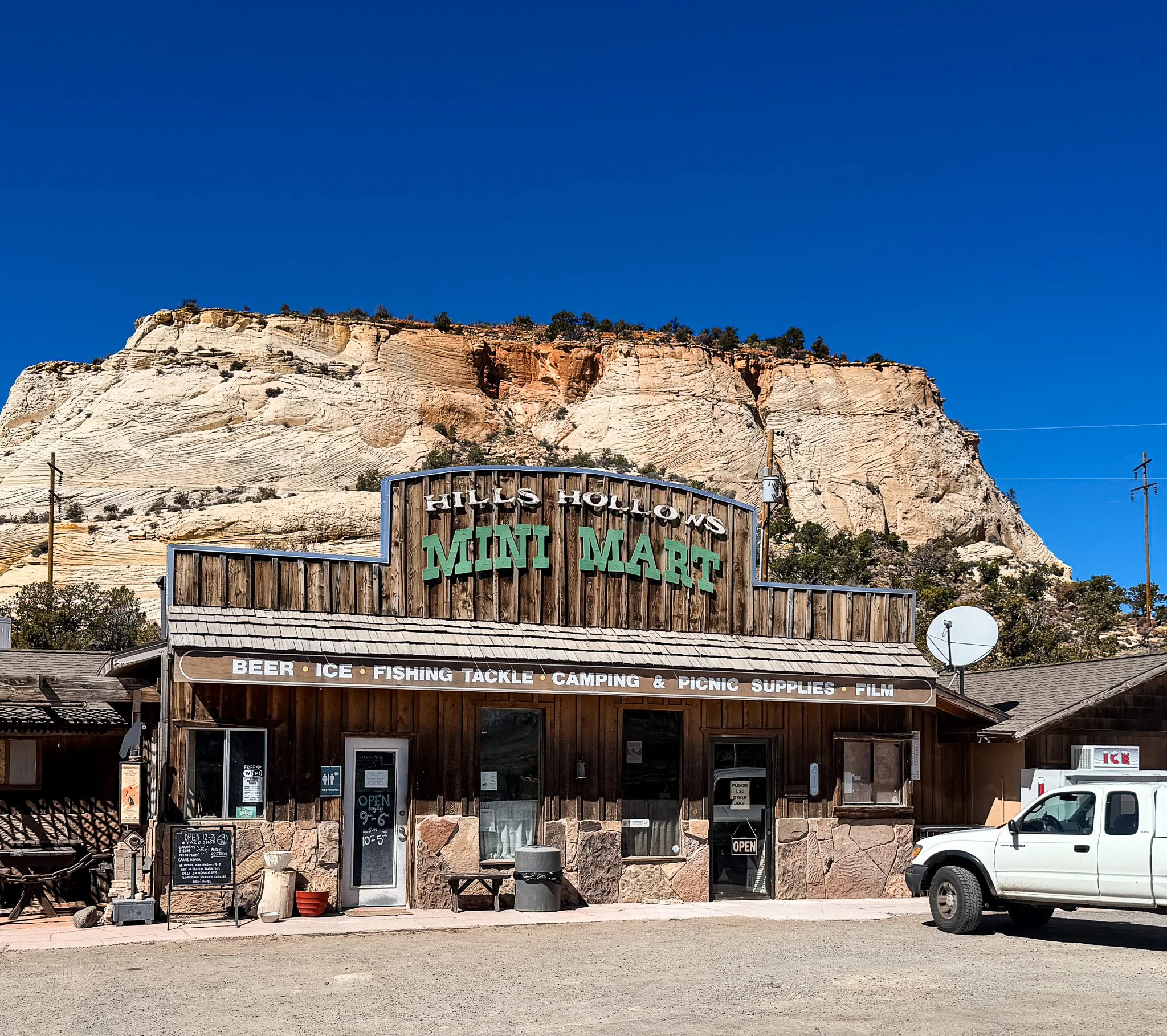
Hills & Hollows Mini Mart in Boulder, Utah — a small grocery and supply stop along Scenic Byway 12.
It’s a small stop, but it adds an entirely different layer to the landscape. After spending time exploring canyons and desert cliffs, it was fascinating to see evidence of people who once lived in this region long before modern roads connected these towns.
Lower Calf Creek Falls
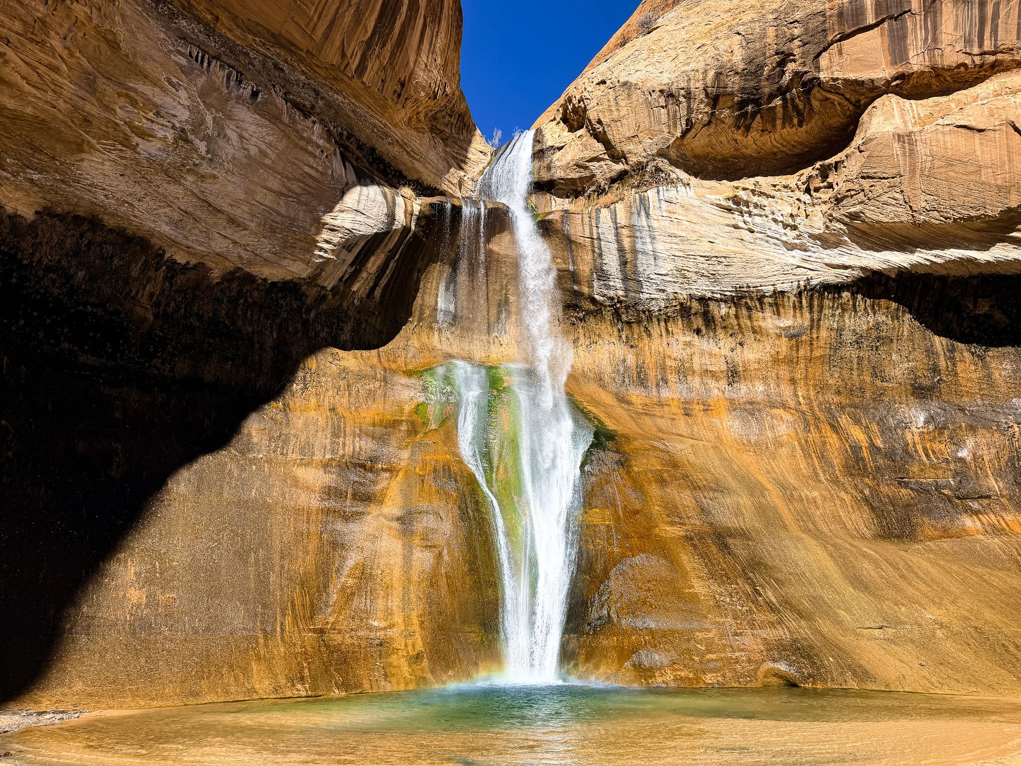
Lower Calf Creek Falls cascading 126 feet into a desert pool inside Grand Staircase–Escalante National Monument in southern Utah.
Lower Calf Creek Falls was a stop for me because I was ready to settle in and camp. The campground there is small, but the location is incredible. A creek runs through the middle of the campground, and there’s a small swinging bridge you cross to reach the other side. The whole area sits tucked between cliffs, with trees providing shade and the sound of nearby running water.
What makes the spot even better is that one of the most rewarding hikes in the area starts right from the campground.
One of the most memorable hikes I did around Grand Staircase–Escalante National Monument was to Lower Calf Creek Falls.
Lower Calf Creek Falls flowing into a desert pool in the middle of the Escalante landscape.
The trail winds through a wide desert canyon before eventually reaching a 126-foot waterfall pouring down from the cliffs into a pool below. Seeing a waterfall like that in the middle of the desert feels almost unexpected. It is a gorgeous oasis. Worth the hike to see this waterfall.
Camping there made the experience even better. Being able to hike the trail during the day and then spend the evening in the canyon made this one of my favorite stops in the Escalante area.
You can view the trail on Trailforks here. I recommend downloading Trailforks before your trip because there is little to no cell service in this part of the monument. A subscription is required to access maps offline.
Watch my hike to Lower Calf Creek Falls: Coming soon.
Lower Calf Creek Falls Trailhead: 37.7945, -111.4158
Peek-a-Boo and Spooky Slot Canyons
Another highlight of the trip was hiking through Peek-a-Boo and Spooky Gulch. This was an incredible experience and, in my opinion, one of the hikes you should absolutely do while visiting the Escalante area.
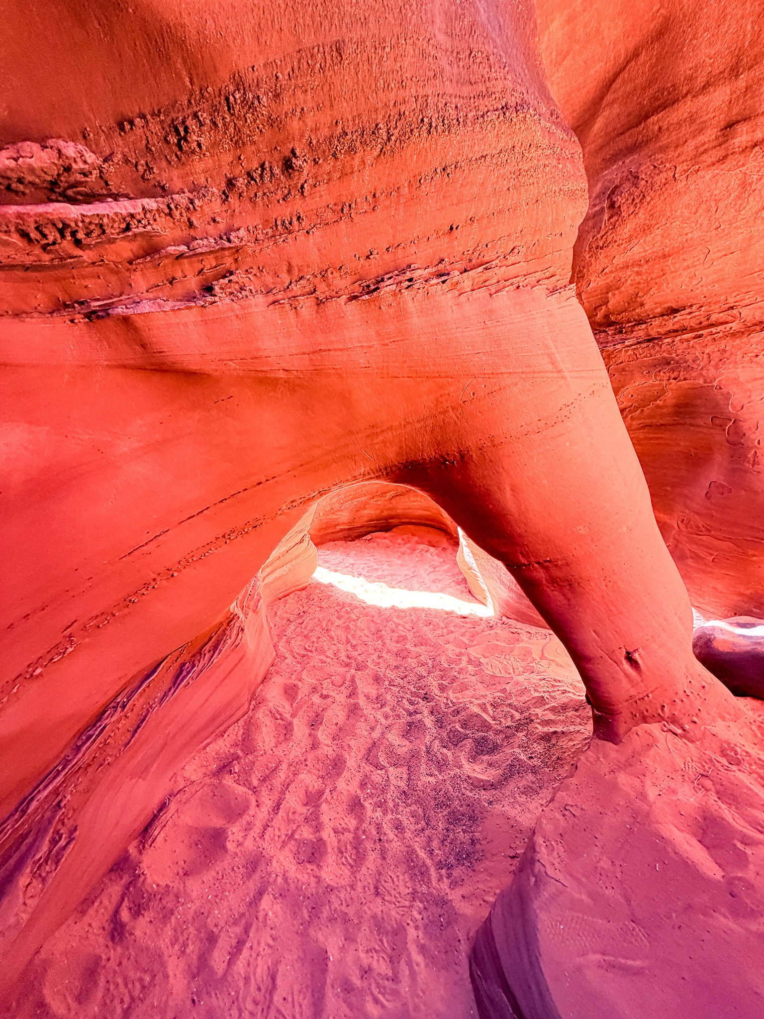
Sculpted sandstone formations inside Peek-a-Boo Slot Canyon in Grand Staircase–Escalante National Monument.
Getting there requires driving several miles down a long, bumpy gravel road to reach the Dry Fork trailhead. When you arrive, you’ll see a parking lot on the left that usually has quite a few cars. Near the trailhead, there is also a narrow metal slot gauge — similar to the luggage size gauges at airports. If you can fit through that opening, you should be able to make it through the tightest sections of the canyon.
From the parking area, the hike begins on the Upper Dry Fork Trail for about 0.8 miles. When the trail forks, take the right fork toward Dry Fork Narrows. That section of the hike is about 0.7 miles and is beautiful on its own, winding through desert terrain before you reach the entrance to Peek-a-Boo.
Getting into Peek-a-Boo requires climbing up a short but challenging sandstone wall. I actually had to get help from another hiker to make it up. Without that boost, I probably would not have gotten into the canyon on my own.
Once inside, the slot canyon becomes a maze of twisting sandstone corridors. In some sections, the canyon walls are so narrow you have to turn sideways to squeeze through.
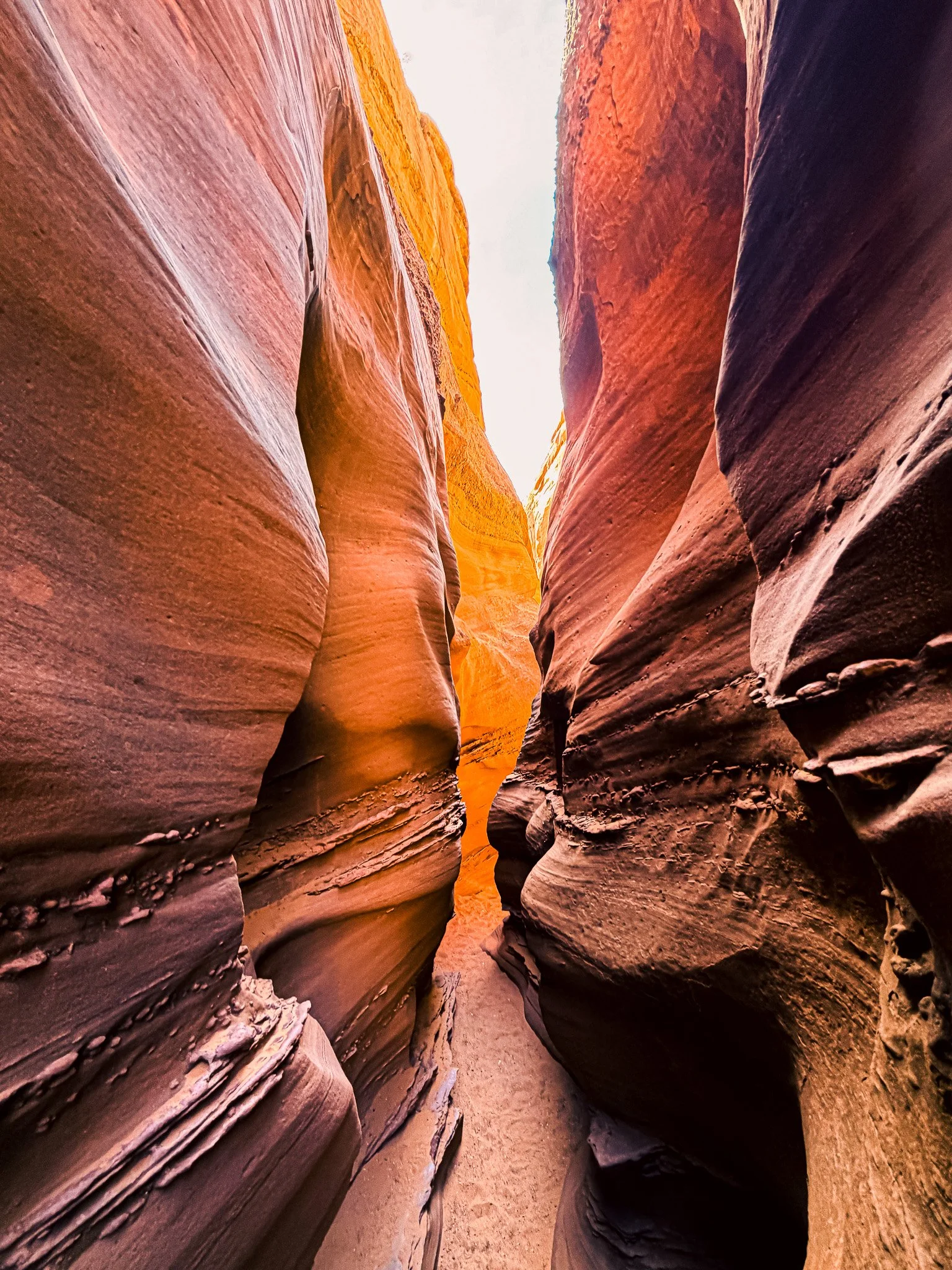
Narrow sandstone walls inside Spooky Gulch slot canyon in Grand Staircase–Escalante National Monument.
The hike involves climbing, scrambling, and navigating tight canyon passages, which makes it feel more adventurous than a typical trail. The total loop through Peek-a-Boo and Spooky Gulch is about 3 miles, but it feels much longer because the canyon sections can be slow and technical. A lot of the time, you’re figuring out how to maneuver through the narrow sections.
It’s easily one of the most memorable hikes in the Escalante area.
Watch my hike through Peek-a-Boo and Spooky Gulch: Peek-a-Boo + Spooky Slot Canyons — Grand Staircase–Escalante National Monument
You can view the trail on Trailforks here. I recommend downloading Trailforks before your trip because there is little to no cell service in this part of the monument. A subscription is required to access maps offline.
Peek-a-Boo & Spooky Gulch Trailhead: 37.4236, -111.4170
Devils Garden
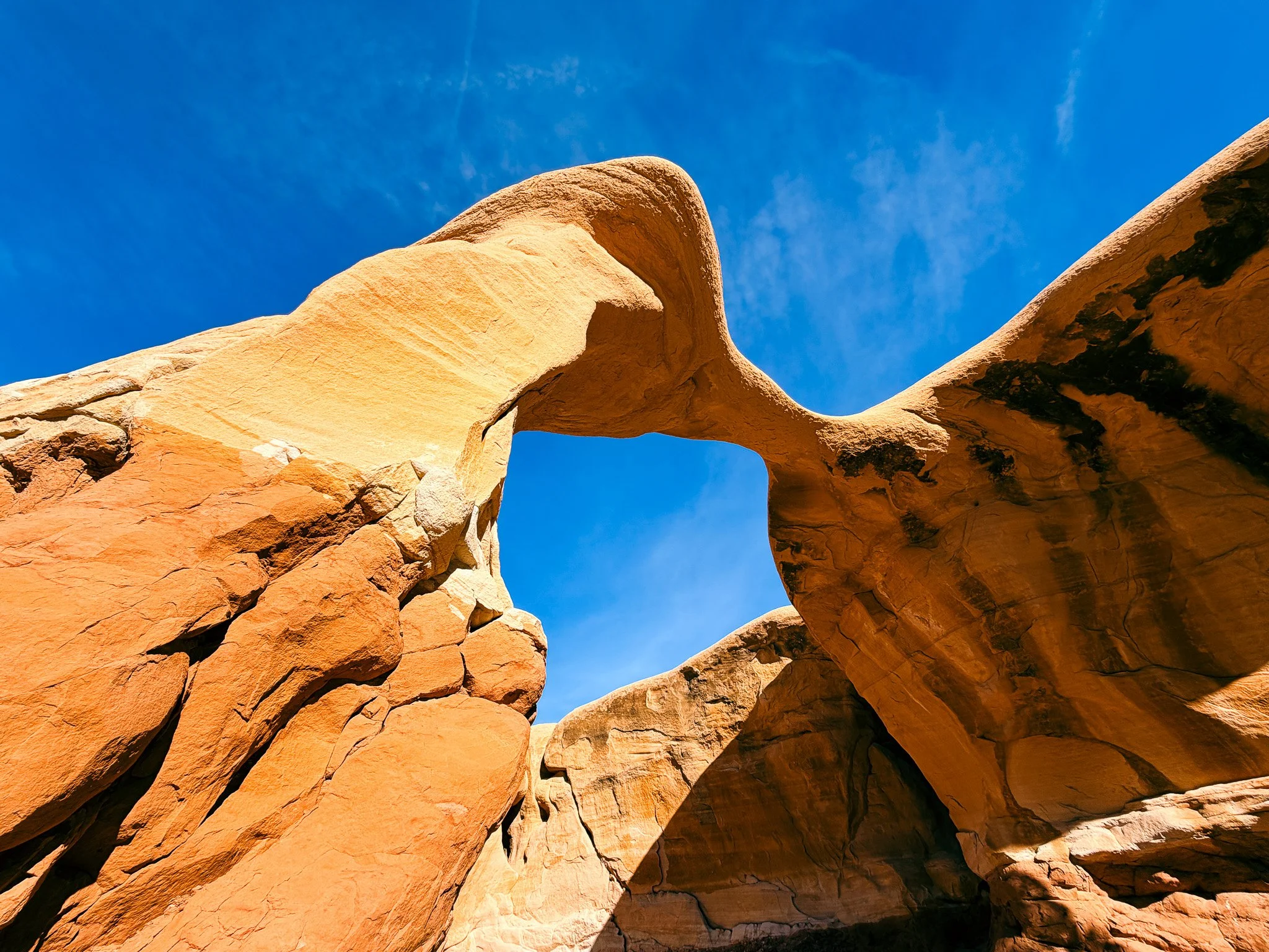
Natural sandstone bridge formation at Devils Garden in Grand Staircase–Escalante National Monument, Utah.
Another stop inside the monument is Devil’s Garden. I got this tip from the college students who helped me through Peek-a-Boo. You don’t have to hike far to get to this. You hop out of your car and it is right there.
This area is filled with unusual sandstone formations, arches, and hoodoos rising out of the desert floor. Unlike many hikes in the region, Devil’s Garden is easy to explore by simply wandering through the formations.
The shapes of the rocks feel almost sculptural, and it’s a fun place to walk around and explore at your own pace. It’s gorgeous.
Devils Garden: 37.4356, -111.5569
Dispersed Camping Near Hole-in-the-Rock Road
One of the things I loved about the Escalante area was the ability to camp out in the landscape.
I stayed at a dispersed campsite just off Hole-in-the-Rock Road. There were a few other campers nearby, but the sites were spread out enough that it still felt quiet and remote.
Camping there made it easy to explore places like Peek-a-Boo and Spooky Slot Canyons and Devils Garden early in the morning before the day got too hot.
At night the skies become incredibly dark, and the stars overhead are some of the brightest I’ve seen in Utah.
Why Escalante Feels So Remote
One of the things that stood out to me about the Escalante area was just how remote it feels.
Unlike many national parks, large parts of Grand Staircase–Escalante National Monument are still accessed by long dirt roads and trailheads that require a little effort to reach.
Even the nearby town of Boulder was once considered one of the most isolated towns in the continental United States. The paved road connecting Boulder to Escalante wasn’t completed until 1940.
Today the region is connected by Highway 12, but the surrounding desert landscape still feels wild and largely untouched.
That sense of remoteness is part of what makes exploring Escalante so memorable.
Final Thoughts
I’m really glad I decided to stop and explore Grand Staircase–Escalante National Monument. Exploring the area ended up being one of my favorite experiences in southern Utah.
Between the slot canyons, desert waterfalls, strange rock formations, and quiet campsites, the landscape feels adventurous and wide open in a way that’s hard to find in more crowded national parks.
If you enjoy places that feel big, wild, and less developed, the Escalante region is one of the most rewarding places to explore in Utah.
More Utah National Park Guides
If you're exploring Utah’s parks, you might also enjoy:
Best Things to Do in Capitol Reef National Park: My Favorite Hikes, Views, and Historic Spots
Grand Staircase–Escalante National Monument: My Favorite Hikes and Places to Explore
I Thought a National Monument Was Small — Then I Saw Escalante
Calf Creek Falls & Campground: One of the Best Stops I Made
Devil’s Garden in Grand Staircase–Escalante National Monument
Peek-a-Boo and Spooky Slot Canyons in Grand Staircase–Escalante National Monument
Michele Underwood writes Overland Girl, where she shares firsthand travel experiences across the American West — from desert landscapes and national parks to small towns layered with history. Her work blends movement, place, and the stories that shape them.

Some posts may include affiliate links to products or services she uses on the road. If you choose to purchase through those links, she may earn a small commission at no additional cost to you. It helps support continued travel and storytelling. She only links to items she personally uses or would use herself.