
Shafer Trail: The Famous Road Through Canyonlands National Park
From cattle route to Canyonlands icon.
Words by Michele Underwood | Photos by Michele
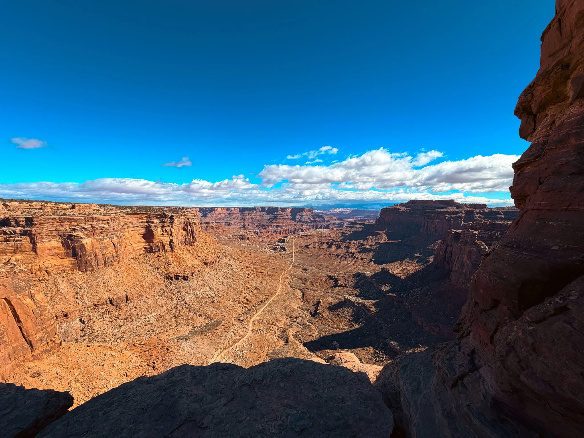
Looking down from Shafer Canyon Overlook at the road winding across the canyon floor below Island in the Sky.
I first learned about Shafer Trail while visiting the Island in the Sky district of Canyonlands National Park. One of my first stops after the visitor center was Shafer Canyon Overlook.
The view is dramatic. Standing on the edge, you are looking 1,500 feet down into the canyon below. I walked out to the furthest ledge I could find, looked down at the switchbacks carved into the cliff, and thought, one day, I want to bike that and drive that road.
The switchbacks immediately caught my attention.
From the overlook, I could see the road zigzagging down the cliff face toward the canyon floor. Looking down from above, it was easy to see why Shafer Trail has become one of the most photographed roads in Utah.
People stop at the overlook to take pictures, drive the switchbacks in high-clearance vehicles, or use it as the gateway to the White Rim Road.
What many visitors do not realize is that Shafer Trail was not built as a scenic drive. Long before it became a destination, it was a working road that played a role in ranching, mining, and the history of southeastern Utah.
What Is Shafer Trail?
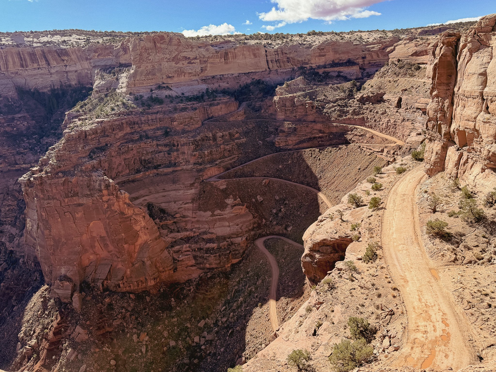
The famous Shafer Trail switchbacks descend 1,500 feet from Island in the Sky to the White Rim below.
Shafer Trail is a dirt road in Canyonlands National Park that connects the Island in the Sky mesa with the White Rim below.
The road descends more than 1,500 feet through a series of switchbacks carved into the sandstone cliffs. At the bottom, it continues across the White Rim and connects to other backcountry routes throughout the park.
For many visitors, the overlook is enough. The view from above gives you a sense of the scale of Canyonlands that is difficult to appreciate from photographs alone.
Others continue down the switchbacks to explore the White Rim Road, one of the most famous backcountry routes in the National Park System.
Where Can You See Shafer Trail?
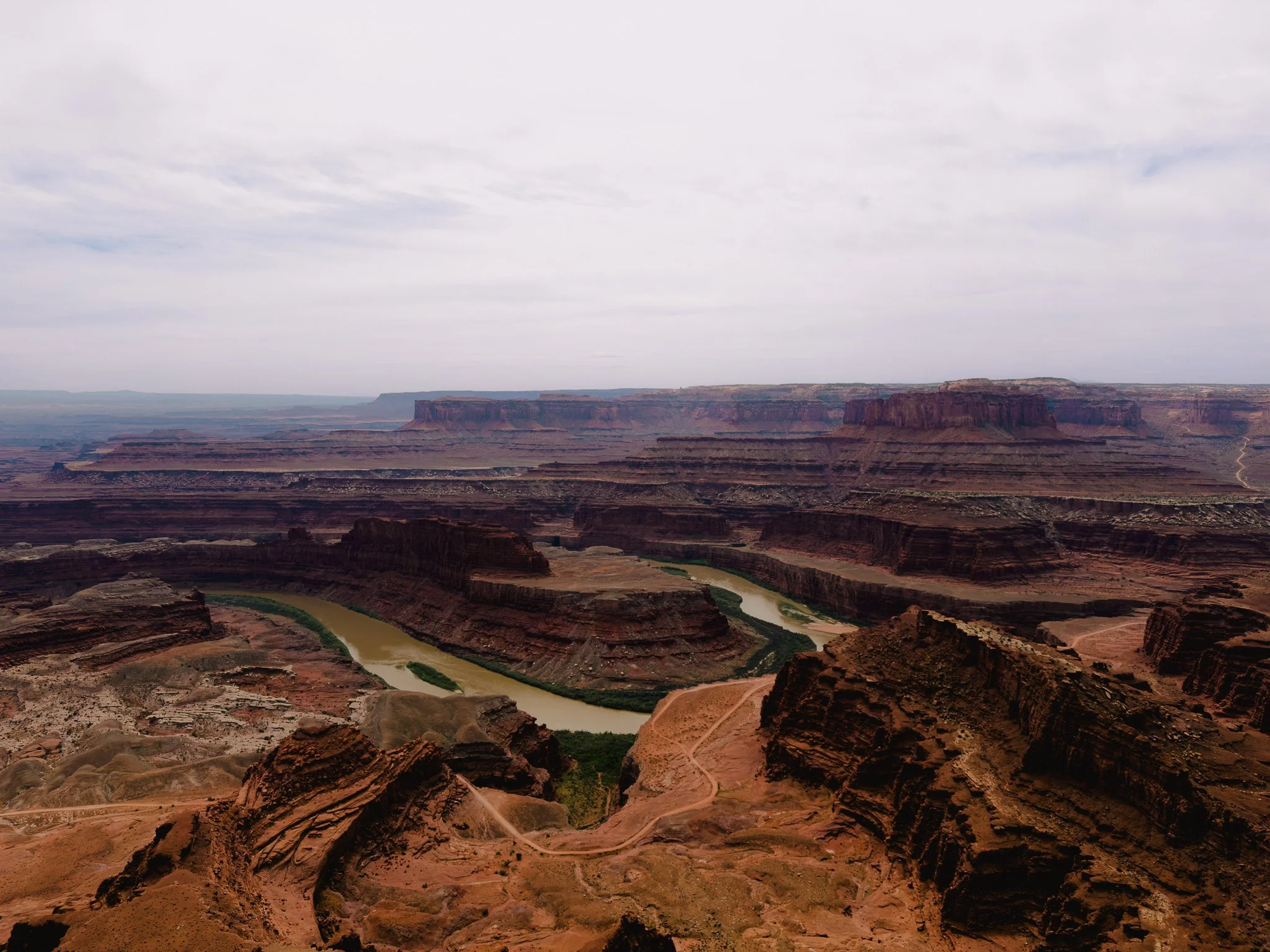
The Colorado River bends through the canyon below Dead Horse Point State Park, with sections of the Shafer Trail route visible in the distance.
One of the best views of Shafer Trail is from Shafer Canyon Overlook in Canyonlands National Park, but it is not the only place to see it.
You can also spot the switchbacks from Dead Horse Point State Park. From several overlooks, you can trace the route from the famous switchbacks below Island in the Sky as it winds through the canyon country toward the Potash ponds near Moab.
Seeing the trail from different angles helps put its scale into perspective. From Canyonlands, you are looking down at the switchbacks as they drop 1,500 feet into the canyon. From Dead Horse Point, you can see how the road fits into the larger landscape of mesas, cliffs, and canyons.
It is one of the reasons I recommend visiting both parks. Together, they provide some of the best views of Shafer Trail and the surrounding canyon country.
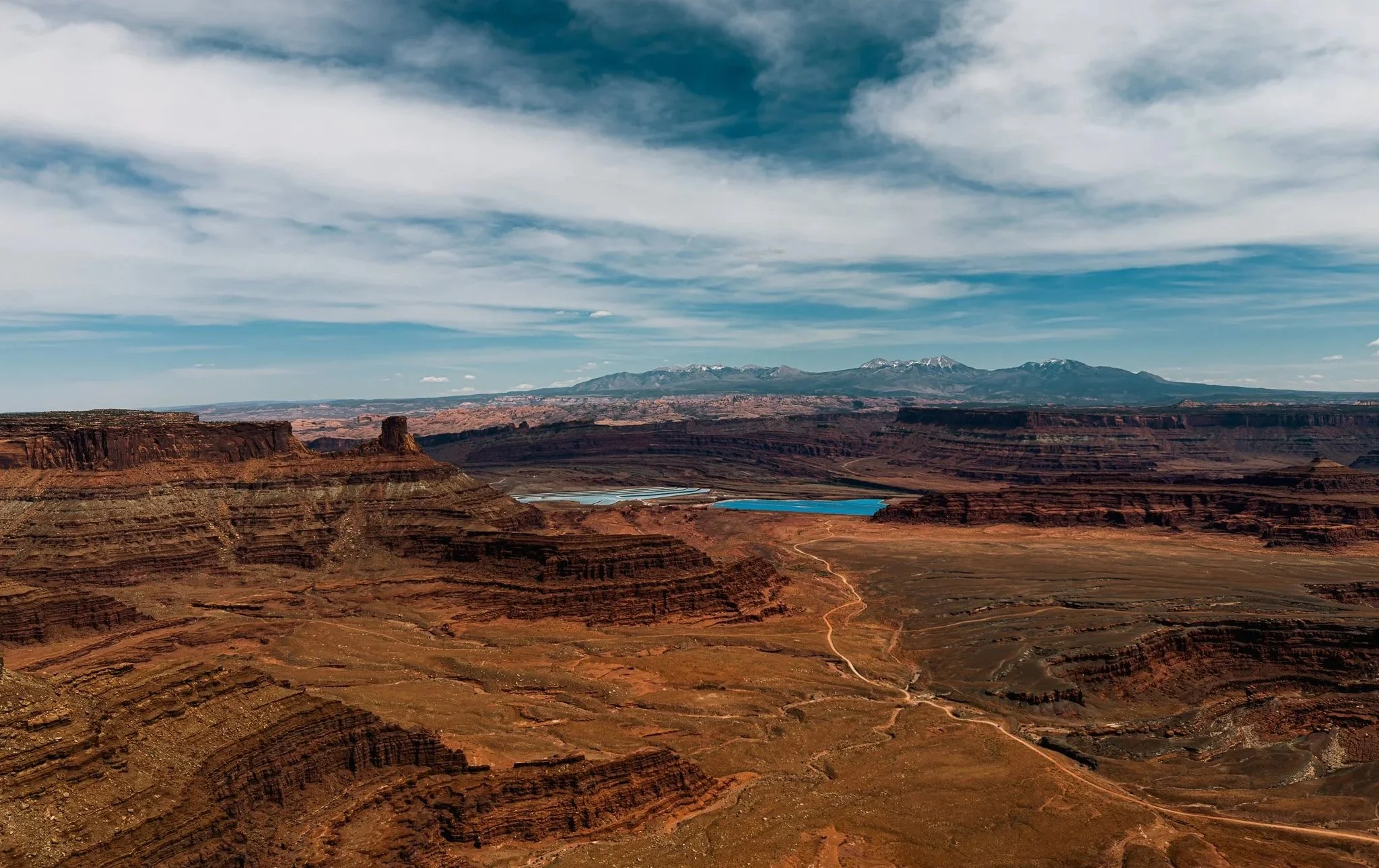
From Dead Horse Point State Park, you can trace Shafer Trail as it winds through the canyon country toward the Potash ponds near Moab.
How Was Shafer Trail Built?
Looking down from the overlook, it is hard to imagine how a road could descend 1,400 feet into the canyon.
The answer is that it did not start as a road.
The route began as a trail used by ranchers moving cattle between the mesa top and grazing areas below. Around 1916, John "Sog" Shafer began improving and widening the route, making it easier to move livestock and supplies through the canyon country.
Rather than cutting straight down the cliff, the trail followed natural ledges and weaknesses in the sandstone. This allowed it to gradually work its way from the top of Island in the Sky to the White Rim below.
During the uranium boom of the 1950s, parts of the route were widened again to accommodate trucks hauling ore out of the canyons.
The switchbacks visitors see today are the result of those improvements. The road uses a series of tight turns to spread the elevation loss across several miles, making it possible to descend more than 1,400 feet without an extreme grade.
That history is part of what makes Shafer Trail so impressive. What looks like a road carved into a cliff face began as a practical route for ranchers long before Canyonlands became a national park.
The Ranching History Behind Shafer Trail
Long before Canyonlands became a national park, ranchers used this landscape to graze cattle.
The Shafer family settled in the area during the late 1800s and needed a way to move livestock between the mesa top and the lower country below. The cliffs that make Canyonlands so dramatic also made travel difficult.
Over time, routes were established that allowed cattle, supplies, and equipment to move between elevations.
The road that visitors know today as Shafer Trail grew from those early ranching routes.
It was not created as an attraction. It was built because people needed a practical way to move through a rugged landscape.
The Uranium Boom
The road took on a new role during the uranium boom of the 1950s.
Southeastern Utah became one of the centers of uranium exploration in the United States. Prospectors spread across the canyon country searching for deposits, and roads became essential for moving equipment and ore.
Shafer Trail provided access between the mesa top and the canyons below. Trucks hauled uranium ore up routes that many visitors now view as scenic drives.
Standing at the overlook today, it is difficult to imagine loaded trucks climbing those switchbacks.
Yet for a period of time, that is exactly what happened.
How Canyonlands Changed Shafer Trail
Everything changed when Canyonlands National Park was established in 1964.
The same landscape that had supported ranching and mining became protected public land. Visitors began arriving to experience the canyons, mesas, arches, and overlooks that make this part of Utah unique.
Shafer Trail remained.
Instead of serving ranchers and miners, it became one of the defining views of Canyonlands.
The road provides a visual connection between the mesa top and the canyon country below. Looking at the switchbacks helps you understand just how massive the landscape is.
That is part of what makes the overlook so memorable.
The road does not dominate the view. It highlights the scale of everything around it.
Can You Drive Shafer Trail?
Shafer Trail is open to vehicles when conditions allow, and many visitors use it to access the White Rim Road.
The route is unpaved and steep, with tight switchbacks and drop-offs along the edge of the cliffs. Conditions can change after rain, so it is always worth checking current road conditions before heading out.
Many people choose to experience Shafer Trail from the overlook.
Others make the descent and continue deeper into Canyonlands.
Pro tip: Driving Shafer Trail itself is different from continuing onto White Rim Road. The National Park Service highly recommends a high-clearance AWD or 4WD vehicle for Shafer Trail. If you continue onto White Rim Road, a high-clearance 4WD vehicle with low-range gearing is required, along with a day-use permit. The road becomes much rougher, with deep sand, rocky sections, and obstacles that are beyond what most standard vehicles are designed to handle.
Both experiences are worth it.
You Can Bike Shafer Trail Too
While most people experience Shafer Trail from an overlook or behind the wheel of a vehicle, it is also part of one of the most famous mountain bike routes in the country.
Many riders encounter Shafer Trail as part of the White Rim Road, a roughly 100-mile loop that circles beneath the Island in the Sky mesa. Guided outfitters offer supported trips that typically take three to four days, allowing riders to focus on the experience while gear, food, and water are transported between camps.
For many riders, the trip begins with the descent down Shafer Trail's switchbacks. What looks intimidating from the overlook becomes the gateway to several days of riding through some of the most dramatic scenery in Canyonlands National Park.
It is one thing to look down at Shafer Trail from above. It is another to spend days riding through the landscape it connects.
Why Shafer Trail Matters
There are plenty of scenic roads in the American West.
What makes Shafer Trail different is the story behind it.
The road connects several chapters of Utah history. Ranchers used it to move cattle. Miners used it during the uranium boom. Today, visitors use it to experience one of the most dramatic landscapes in the country.
Most people arrive because the switchbacks catch their attention.
The longer you spend looking at them, the more you realize the road is more than a photo opportunity.
It is a reminder that long before Canyonlands became a destination, people were finding ways to live and work in this landscape.
Few roads tell that story as clearly as Shafer Trail.
Shafer Canyon Overlook Location
Island in the Sky District
Canyonlands National Park, UtahGPS Coordinates: 38.4589, -109.8185
Michele Underwood writes Overland Girl, where she shares firsthand travel experiences across the American West — from desert landscapes and national parks to small towns layered with history. Her work blends movement, place, and the stories that shape them.
Some posts may include affiliate links to products or services she uses on the road. If you choose to purchase through those links, she may earn a small commission at no additional cost to you. It helps support continued travel and storytelling. She only links to items she personally uses or would use herself.