
Appalachian Trail Series, Part 2: From Springer Mountain to Katahdin
Words by Michele Underwood | Photos by Michele and other contributors
In Part 1, I looked at the big picture—the Appalachian Mountains, Benton MacKaye’s early vision, and how a rough idea turned into a real trail. If you missed that post, you can read Part 1 here.
This post is all about the modern Appalachian Trail: where it officially starts, where it ends, the states it crosses, and how the route flows from Georgia to Maine.
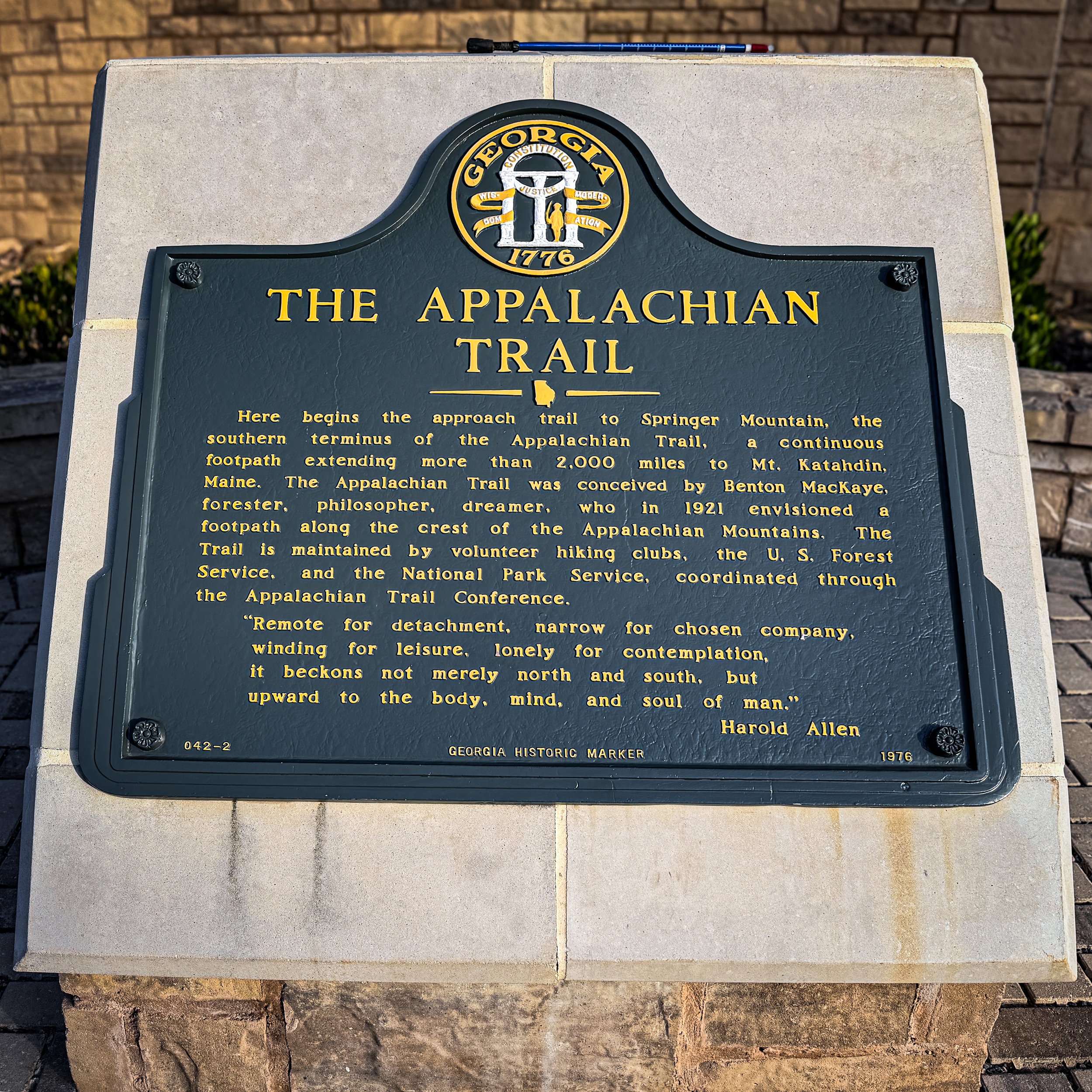
The historic marker at Amicalola Falls explaining the start of the A.T.
Appalachian Trail overview: distance and direction
Today’s Appalachian Trail runs for roughly 2,200 miles along the spine of the Appalachian Mountains. The official mileage shifts slightly every few years as sections are rerouted or refined, but it hovers around 2,197 miles.
The basic idea is simple:
Start on a wooded summit in north Georgia.
Follow ridges and valleys northeast across 14 states.
Finish on a rugged, exposed peak in northern Maine.
On paper it’s a line from Springer Mountain to Katahdin. On the ground it’s everything from smooth forest tread and farm-country ridges to rocky alpine zones and bog boards.
Appalachian Trail southern terminus at Springer Mountain, Georgia
Most A.T. journeys begin—or end—on Springer Mountain, a rounded, tree-covered summit in north Georgia.
Springer quietly became the southern terminus in the mid-1900s, replacing nearby Mount Oglethorpe. Today, it’s the official starting point for most northbound thru-hikers and a big milestone for section hikers.
In reality, though, a lot of northbound hikes start a little farther down the mountain at Amicalola Falls State Park. That’s where many hikers choose to sign in, get their packs weighed, and step onto the Approach Trail.
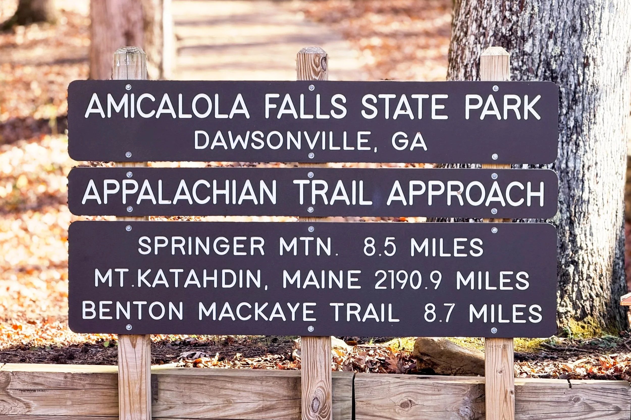
Start of the Appalachian Trail Approach Trail at Amicalola Falls.
A few details about the southern end:
Location: Chattahoochee National Forest, north Georgia.
Check-in: Many northbound hikers start at the Amicalola Falls visitor center, where they can sign in for their hike and grab any last-minute info before heading out.
Approach miles: The Approach Trail from Amicalola Falls adds about 8.5 miles before you even reach the official southern terminus on Springer Mountain, so your first day on trail can be a big one.
First miles on the A.T.: Once you tag the plaque on Springer, the Appalachian Trail heads north on forested ridges with steady climbs and descents—early miles to figure out pacing, pack weight, and trail routines.
If you’ve hiked around Amicalola Falls or North Georgia’s state parks, you’ve already been in the orbit of these first Appalachian Trail miles.
Appalachian Trail northern terminus at Katahdin, Maine
On the other end of the line is Mount Katahdin in Baxter State Park, Maine. If Springer feels like a quiet gateway into the trail, Katahdin feels like a hard-earned finale.
Katahdin is steep, rocky, and exposed compared to Springer’s forested summit. Weather can shut down summit attempts, and the park has its own rules and limited season. For northbound thru-hikers, this is the final climb after months of living on trail. For southbound hikers, it’s Day 1.
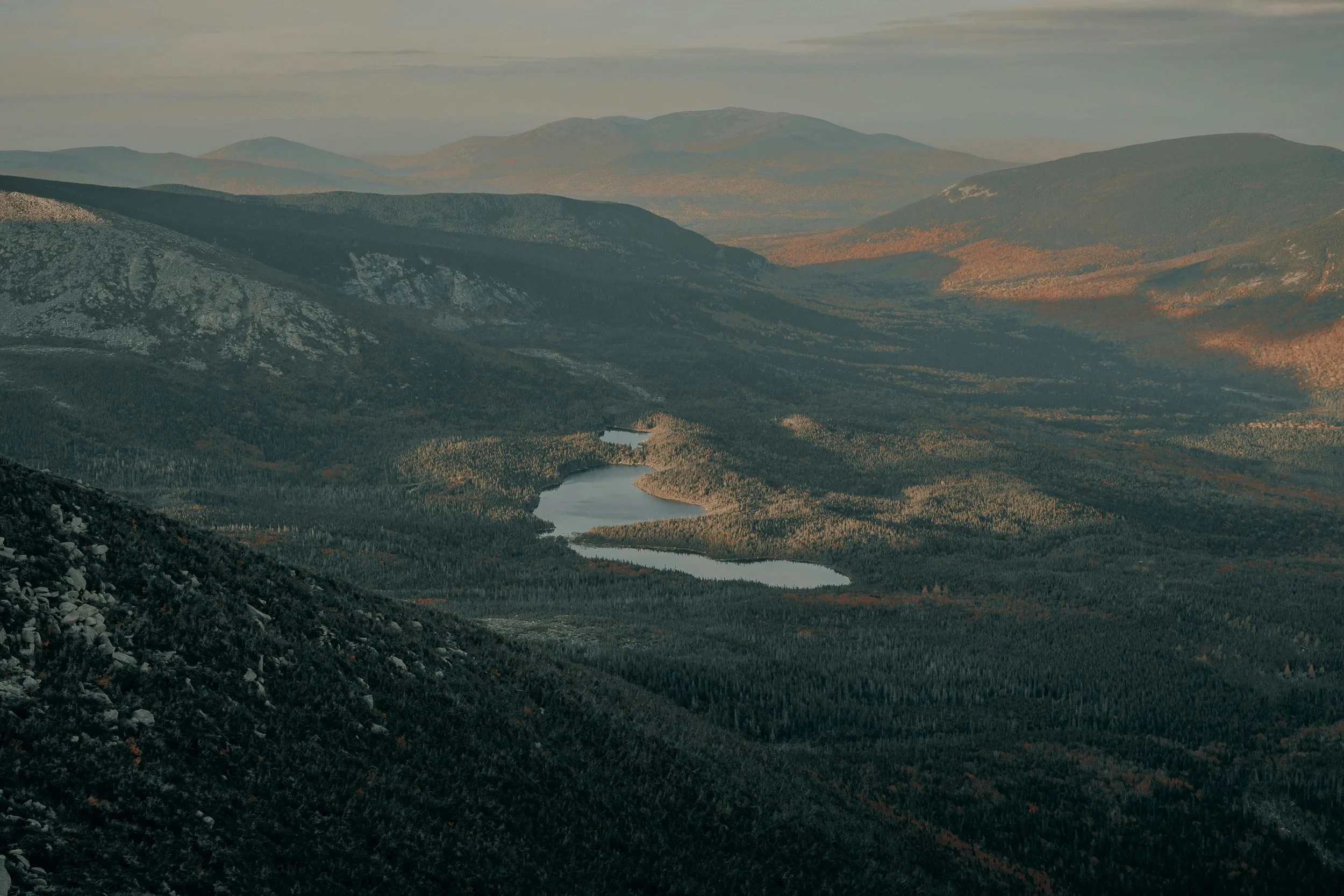
Northern Maine lakes and ridgelines near the A.T. Photo by Clay Banks
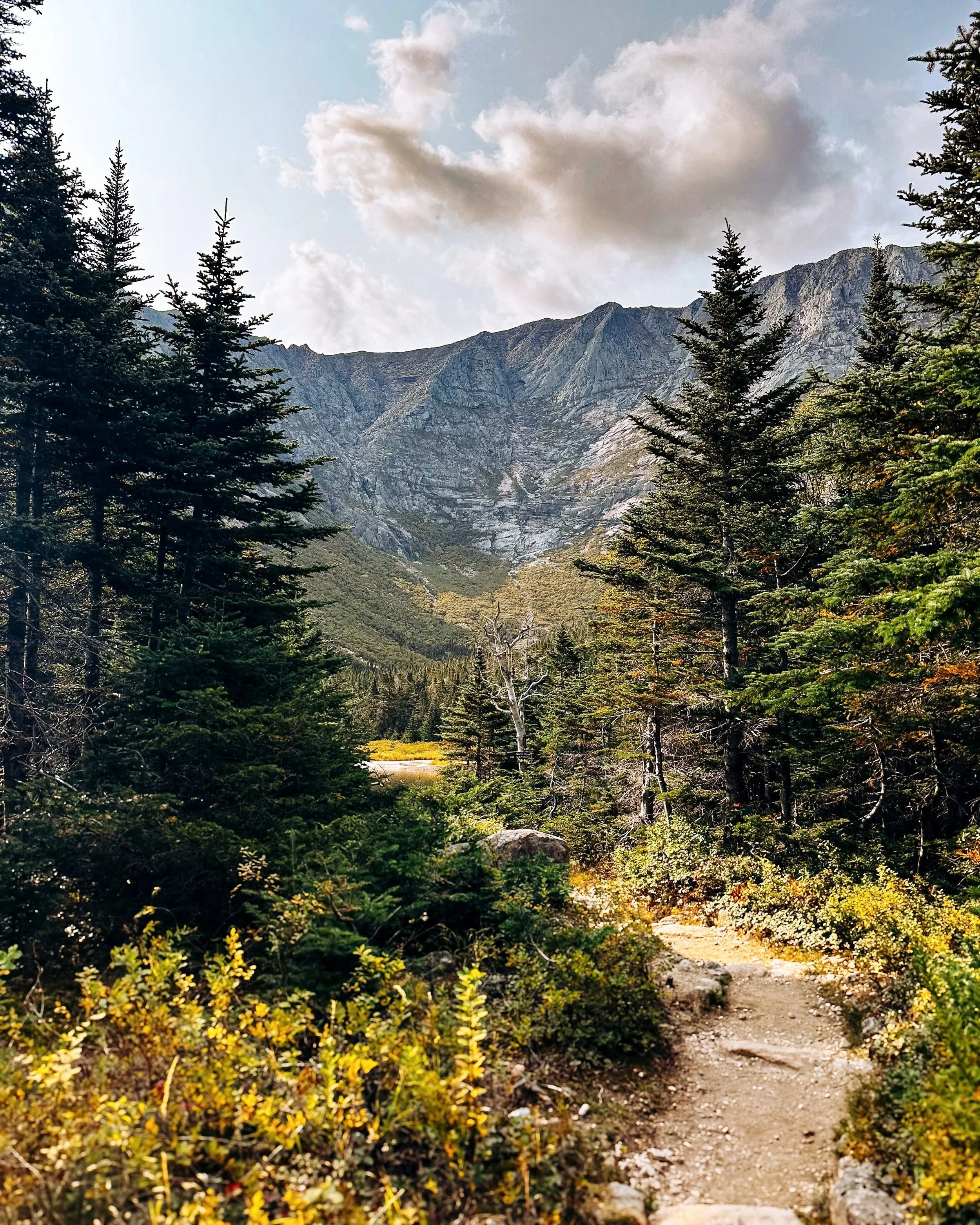
Early views heading toward Katahdin. Photo by Sarah Swainson
A few details about the northern end:
Location: Baxter State Park, northern Maine.
Character: Big views, rock scrambling, and serious weather if it rolls in.
Symbol: The wooden Katahdin sign has become one of the most photographed spots on the entire A.T.
Springer to Katahdin is the classic description, but it’s these two very different endpoints that give the Appalachian Trail its emotional bookends.
Appalachian Trail states list
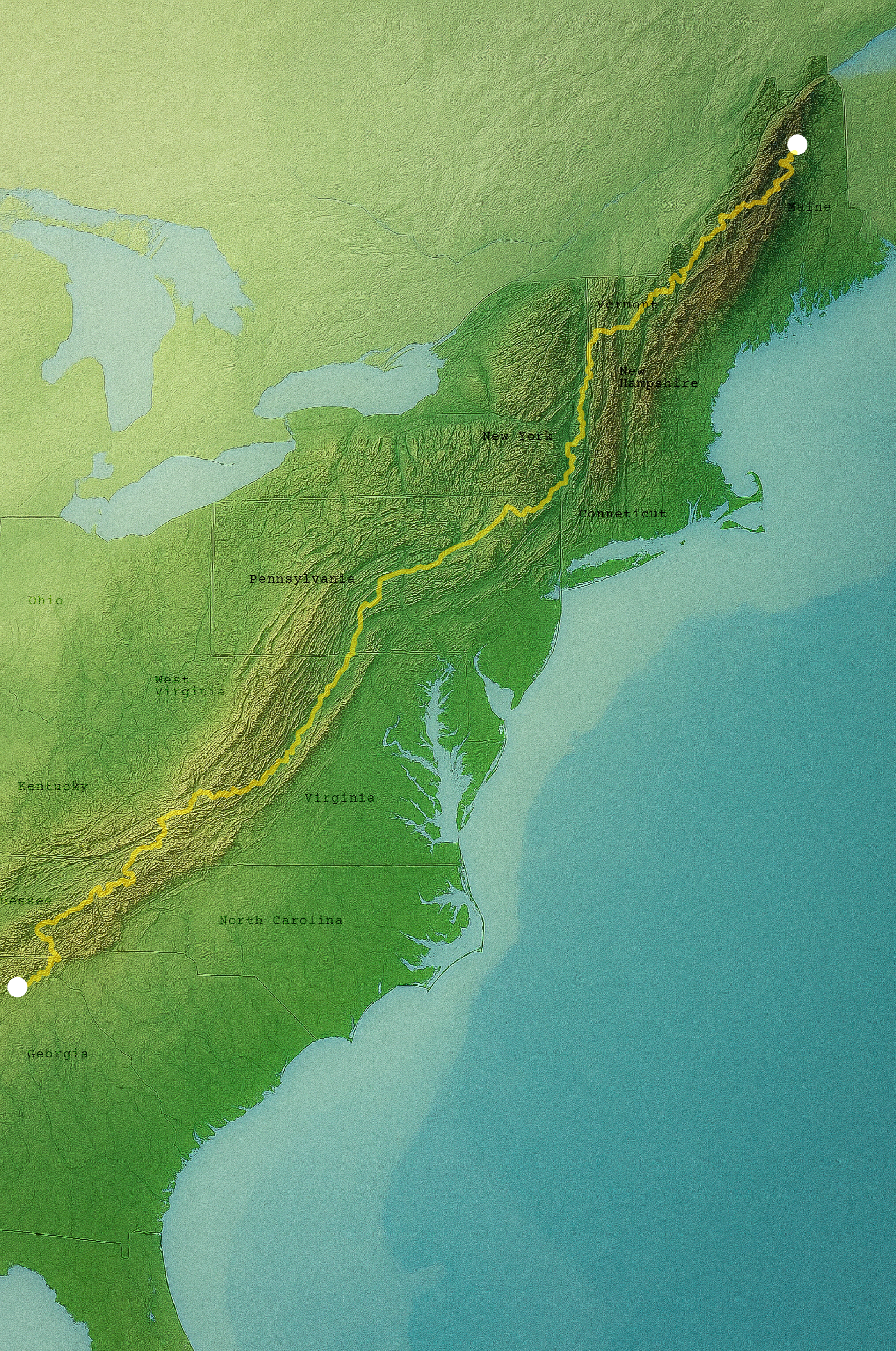
The full route of the Appalachian Trail, stretching from Springer Mountain in Georgia to Mount Katahdin in Maine, following the spine of the Appalachian Mountains across 14 states.
Between Springer Mountain and Katahdin, the Appalachian Trail passes through 14 states:
Georgia
North Carolina
Tennessee
Virginia
West Virginia
Maryland
Pennsylvania
New Jersey
New York
Connecticut
Massachusetts
Vermont
New Hampshire
Maine
Some states flash by in a few days. Others—looking at you, Virginia—stretch on for hundreds of miles.
Appalachian Trail by region
You don’t have to memorize mile markers to understand the A.T. It’s easier to picture it in a few big regions.
01 Georgia’s section of the Appalachian Trail
Georgia is the warm-up. It holds a relatively short stretch of the A.T., but it’s still a real test for new legs and heavy packs.
Expect:
Steady climbs and descents on forested ridges.
Classic southern Appalachians views in leaf-off season.
Crowded shelters and campsites during peak northbound thru-hiker season.
02 North Carolina and Tennessee sections of the Appalachian Trail
North of Georgia, the A.T. weaves along or near the North Carolina–Tennessee border for long stretches.
Highlights include:
Higher elevations and cooler temperatures.
Open balds and ridgelines with big views on clear days.
A significant chunk of trail through Great Smoky Mountains National Park, with its own rules around camping and permits.
This is where the trail starts to feel bigger—higher peaks, longer climbs, and more dramatic weather.
03 Virginia and Mid-Atlantic sections of the Appalachian Trail
Virginia alone accounts for about a quarter of the Appalachian Trail. It’s long, varied, and a huge mental milestone for thru-hikers.
In Virginia and the Mid-Atlantic, you’ll find:
Open meadows and farmland views alongside green-tunnel forest.
High country around Mount Rogers and Grayson Highlands with chances to see wild ponies.
The famous McAfee Knob overlook.
Harpers Ferry, West Virginia, is often called the psychological halfway point and is home to the Appalachian Trail Conservancy’s headquarters.
North through Maryland, Pennsylvania, New Jersey, and New York, the trail mixes rocky ridges, small towns, and river crossings. Pennsylvania’s rock fields have earned it the nickname “Rocksylvania” for a reason.
04 New England sections of the Appalachian Trail
New England shifts the tone again—more roots, more rocks, more rugged weather.
Connecticut and Massachusetts bring river walks, rolling hills, and some classic New England towns along the way.
Vermont shares a trail with the Long Trail through the Green Mountains.
New Hampshire raises the stakes with the White Mountains—steep climbs, alpine zones, and unpredictable conditions above treeline.
Maine opens with the remote 100-Mile Wilderness and ends with the climb up Katahdin.
By the time you stack all of these regions together, that simple Springer-to-Katahdin idea covers a huge range of terrain and trail styles.
Why Appalachian Trail start and end points matter
Knowing the basic structure of the Appalachian Trail—Springer to Katahdin, 14 states, and a few major regions—makes everything else easier to understand.
You can:
Plan realistic section hikes without feeling like you have to take on the whole trail.
Match trips to the type of terrain you want, whether that’s warm-up ridges in Georgia or big alpine miles in New Hampshire and Maine.
See how other trails you might hike one day—like the Pinhoti or the Benton MacKaye Trail—connect into the same long mountain system.
Part 1 looked at how the A.T. came to life. Part 2 put pins on the map. Next up in this series, I’ll get into how people actually hike it—thru-hikes, section hikes, and shorter trips that still feel like real Appalachian Trail time.
In this post, I’m sticking to the big picture—where the trail runs and how it’s laid out. In the next part of this series, I’ll get into the details of actually starting a hike on the A.T.: Amicalola vs. Springer, what “tagging the plaque” means, and how those first official miles work.
Michele Underwood writes Overland Girl, where she shares gear she uses on real trips—from the Northwoods of Wisconsin to the Ozarks. She values quality and craftsmanship in everything she buys—from outdoor gear to everyday clothes and furniture. Her choices may seem expensive to some, but she believes in buying less and buying better. Longevity matters, both in terms of function and style. Her couch is five years old and still sold at Design Within Reach—that's the kind of timelessness she looks for. Some of the links in this review are affiliate links, which means she may earn a small commission if you buy through them. It doesn’t cost you anything extra, and it helps support her work. She only recommends gear she’d bring herself.