
Riding the Kokopelli Trails in Fruita, Colorado
First impressions from my first two days riding the Kokopelli Loops in Fruita
Words by Michele Underwood | Photos by Michele
I rode the Kokopelli Trails for the first time yesterday and headed back out again today.
Kokopelli feels different the moment you start climbing onto the mesa. More exposed. More rugged. More serious in the way Western Colorado riding can be when the trail turns to ledge rock, the wind cuts across the mesa, and the views stretch forever. It isn’t polished or playful like some of Fruita’s other systems. It asks you to stay switched on.
This article covers what Kokopelli feels like to ride, where it fits into a Fruita mountain biking trip, and my early takeaways after two days of getting to know the terrain.
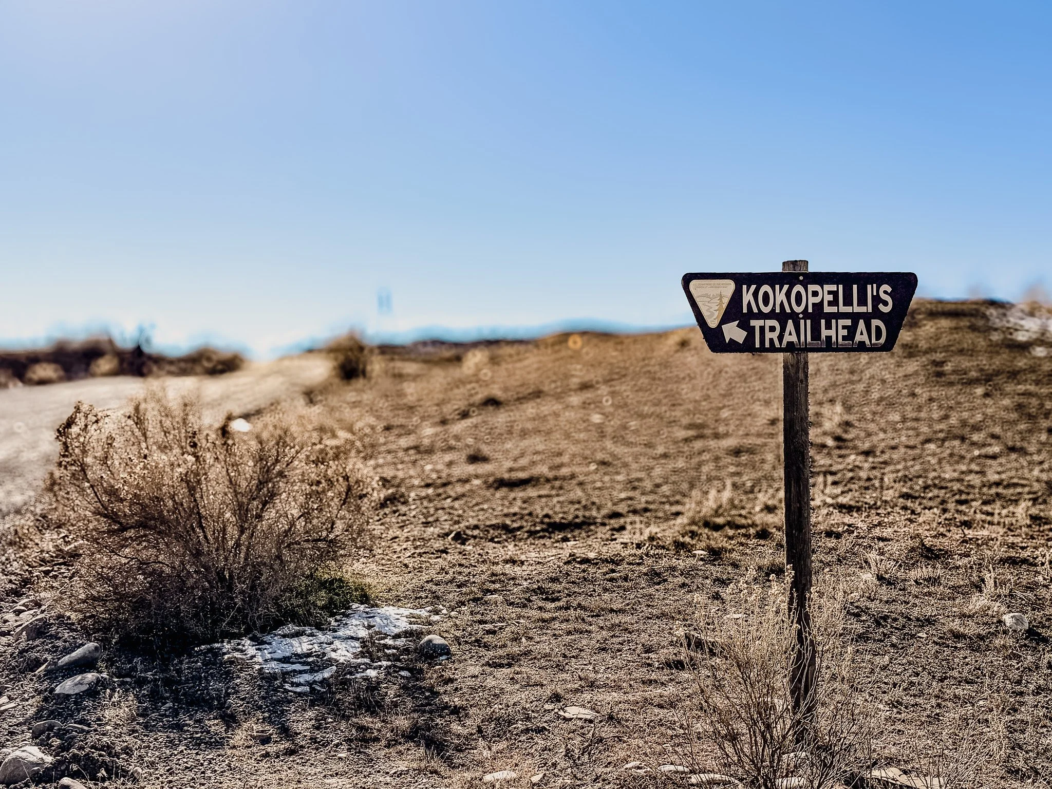
Kokopelli Trailhead — once you’re up here, it’s all open mesa and big sky.
Where the Kokopelli Trails Are Located
The Kokopelli trail network sits east of Fruita and Loma, riding high desert mesas above the Colorado River corridor. It feels farther from town and more remote than places like 18 Road. The landscape opens wide, with long ridgelines, cliffs dropping away in the distance, and very little shade.
It is classic Western Colorado scenery: red and tan rock, sparse vegetation, and big skies.
Approximate main Kokopelli trailhead coordinates: 39.0667° N, 108.8233° W.
Parking and Trailhead Options
Main lot + Saddle Up approach
The main parking area puts you onto Saddle Up, which you ride to reach the rest of the system. It adds a bit of warm‑up mileage before you get into the core trails and is a straightforward option if you’re riding deeper into the network.
Approximate coordinates: 39.0667° N, 108.8233° W.
Parking at the end of Saddle Up
You can also drive to where Saddle Up ends and park there. From this spot you get more direct access to Mary’s, Moore Fun, and Rustler’s Loop, which makes it easier to jump straight into riding without extra connector miles.
Approximate coordinates: 39.0735° N, 108.8320° W.
Lion’s direct trail access
If you drive farther up Lion’s, there are additional pull‑outs and parking areas that let you roll right onto Wrangler and Hawkeye from the lot. This is a good option if those trails are the main focus of your day.
Approximate coordinates: 39.0790° N, 108.8425° W.
Trail Management & Local Support
The Kokopelli Loops trail system is managed by the Bureau of Land Management (BLM), with major support from COPMOBA (Colorado Plateau Mountain Bike Trail Association), the local trail organization responsible for building and maintaining many of the Fruita and Grand Junction mountain bike trails.
If you ride here and love it, consider supporting their work. You can find official trail information on the Grand Valley Trails here: COPMOBA Kokopelli Loops.
What the Terrain Feels Like
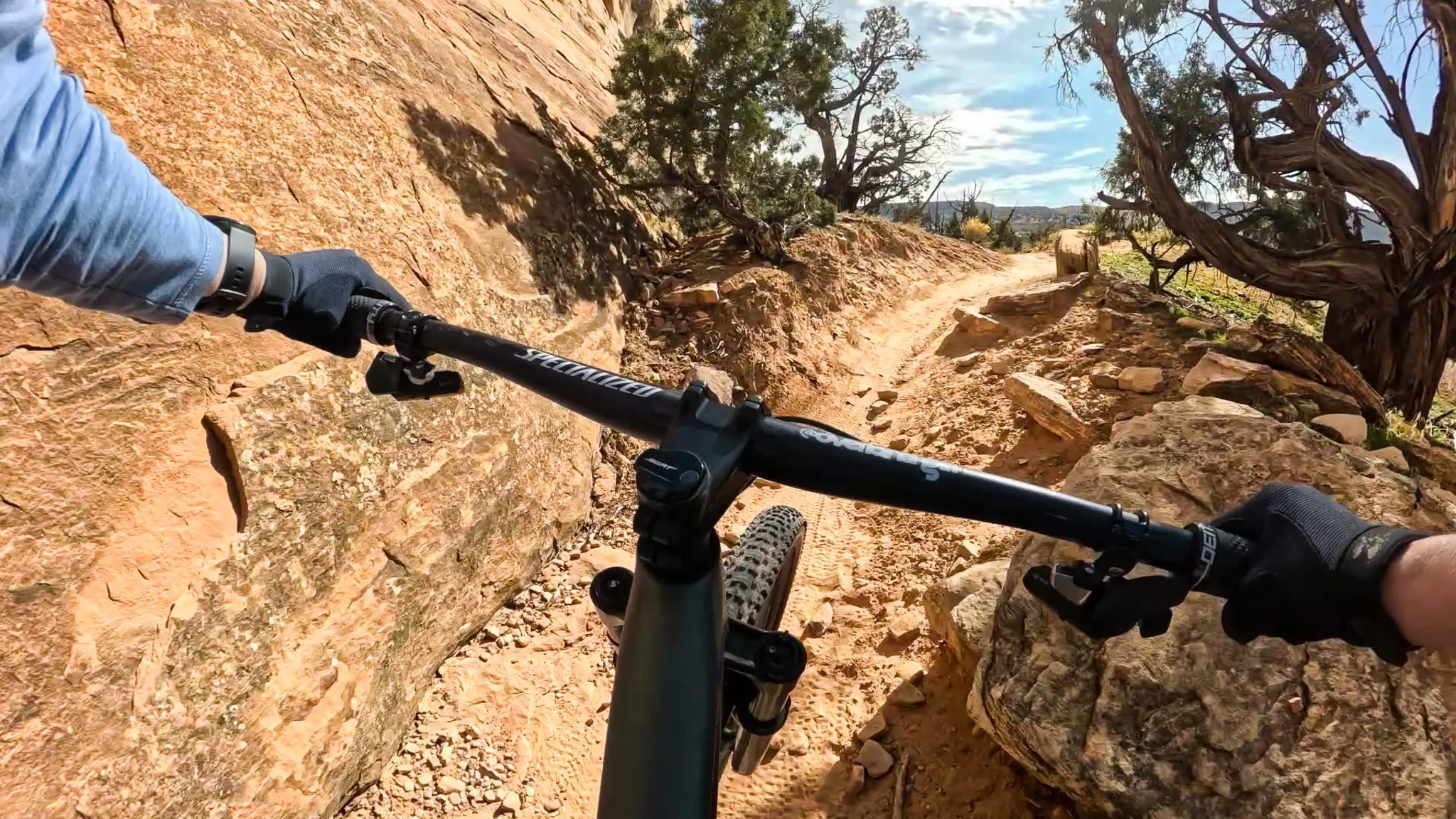
Threading through ledge rock at Kokopelli — this is where you stay light on the bars and commit to your line.
Kokopelli sits on BLM land east of Fruita and Loma, on high desert mesas above the Colorado River corridor.
Expect:
Ledge climbs, chunky sections, and slickrock slabs that make you think quickly about your line choice
Sandy corners and berms
Exposed ridges
Long stretches where you can go for miles without it feeling as exhausting as some other places I’ve ridden
What surprised me most is how far you can go without it feeling relentlessly punchy. The mileage stacks up, but the riding flows in a steady, sustained way rather than constant short bursts of climbing and descending.
Compared to some of Fruita’s more flow-focused trail systems, Kokopelli leans technical and physical. It feels less like stacking playful laps and more like committing to a long desert route across a big piece of landscape.
How Kokopelli Compares to Other Fruita-Area Trail Systems
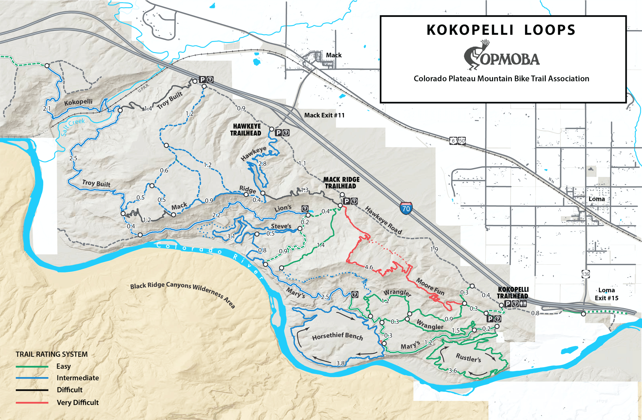
Official Kokopelli Loops trail map from COPMOBA showing the full network across the mesas above the Colorado River.
Kokopelli is one piece of a bigger Western Colorado riding puzzle, alongside places like 18 Road and the Lunch Loops network near Colorado National Monument in Grand Junction.
Kokopelli feels like long-distance desert riding, which is the style I gravitate toward more than downhill-heavy laps where you climb back up and repeat. The routes move across big stretches of terrain, and each trail seems to frame the landscape a little differently—sometimes rolling through grassy mesas, other times riding along edges that look down toward the Colorado River.
Compared to the more downhill-leaning, flow-forward reputation of 18 Road and the steeper, more committing terrain around Lunch Loops and the Monument, Kokopelli comes across as expansive and route-driven—less about repeating short descents and more about moving steadily across a big piece of landscape.
Of the three trail systems, Kokopelli is my favorite so far. That has nothing to do with which is better overall. It just lines up with the kind of riding I like to do.
Trails I Rode
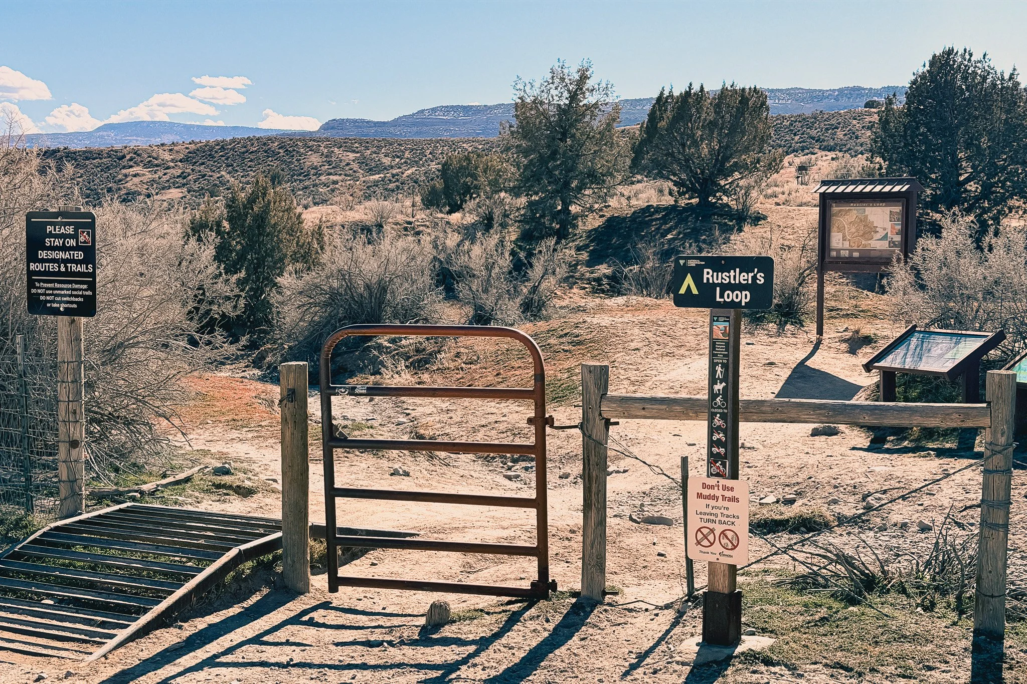
Rustler’s Loop trailhead — my first ride at Kokopelli and still my favorite so far.
I only rode one trail on my first day. Multiple people told me to start with Rustler’s Loop.
It’s a 3.7-mile lap that’s mostly flow, with a few rocky sections where you can pick different lines. Each time I rode it, I cleared more and more as I got familiar with the features and line choices. This is the trail locals ride to warm up.
Rustler’s Loop is my favorite trail out there. It’s fun, has a little tech, flows well in sections, and can be fast. It’s a great first ride if you’re new to desert riding—especially for getting used to rocks, ledges, and climbing over them.
You can check out my video on the trail below.
Basically, the locals gave me a short list of what to ride next, ending with Horsethief Bench. You can check out my video for my first ride on Horsethief Bwench below.
On another day, I rode Rustler’s Loop again and cleared more rock features and picked lines with more confidence. I also rode part of Mary’s and then connected to Wrangler’s Cutoff, including a one-mile blue downhill section of Wrangler’s that was fast, fun, and surprisingly challenging.
I also rode Mary’s again but took it furtner and took the blue Wranlger cutoff to green Wranlger to green Wrangler cutoff back to Mary’s for some chunku funky downhill to the van. I loved this route.
Other Kokopelli Trails to Know (Based on Local Recommendations)
These are specific trails locals kept pointing me toward that I haven’t ridden yet—mentioned for mileage, scenery, or how they fit into bigger Kokopelli days.
Wrangler: 5 miles
Wrangler is a mix of blue and green miles. Riders described it as a good way to add speed after long traverses across the mesa, rather than as something you ride in isolation.
See Wranlger on Trailforks.
Moore Fun: 4.5 miles
Moore Fun is widely talked about as one of the hardest trails in the Kokopelli system—labeled double‑black and very technical.
Locals described it as slow, precise riding with big rock moves, ledges, awkward climbs, and sections where you’re working feature‑to‑feature instead of flowing. It’s the kind of trail you go into expecting to session lines, walk a few things, and spend more time problem‑solving than covering miles.
See Moore Fun on Trailforks.
Steve’s Loop: 3.3 miles
Steve’s Loop got mentioned as a longer‑feeling circuit compared to Rustler’s, with more sustained riding and classic mesa terrain. Locals framed it as one to ride when you’re in the mood for distance instead of quick laps.
See Steve’s Loop on Trailforks.
Hawkeye: 2.9 miles
Hawkeye offers views and a more remote feel, especially compared to the trails closer to the parking areas. People talked about it as one of those routes where you really notice how far out into the landscape you are.
See Hawkeye on Trailforks.
Difficulty and Who Kokopelli Is For
Kokopelli generally suits intermediate to advanced riders, but parts of the system—especially Rustler’s Loop—can work for confident beginners who don’t mind hopping off and walking a few sections while they get used to desert riding. There are a few climbs over rocky sections that might take some getting used to.
It feels like a good fit for:
Intermediate to advanced riders
Confident novices looking to build desert skills
Anyone who likes long, steady rides over lap-based downhill runs
Riders who are comfortable picking lines through rock and ledges
People who enjoy exposure and big, open landscapes
True beginners may find a lot of the system intimidating at first, but patient riders who are willing to dismount occasionally, study lines, and take their time can still have a good experience on select trails.
Fitness matters too. The climbs aren’t always brutal, but the distance and constant engagement add up over time. This is the kind of place where pacing yourself pays off.
Using Trailforks at Kokopelli
I had cell service out there, but I’d still recommend a Trailforks subscription—especially in a place like Kokopelli where you can ride a long way into open landscape with very little around you.
It was useful for:
downloading offline maps before rolling out
seeing how far routes really stretch
checking how much farther I had left on the trails I picked
understanding connectors and options
keeping an eye on elevation gain
figuring out where you are relative to trailheads and roads
With how spread out everything feels, having maps saved on your phone is just smart planning, even on days when your signal looks fine at the start.
Final Thoughts
Kokopelli surprised me in the best way. I have not ridden in the desert before. I came in unsure how I’d feel about desert riding and left loving it.
What stuck with me most was the scale—how far the trails reach, how much space you cover in a single ride, and how the scenery keeps shifting as you move across the landscape. Even the dirt changes color.
Rustler’s Loop was the perfect introduction, and the rest of the system already has me planning return rides for Steve’s Loop, Wrangler, and Hawkeye.
If you like long desert rides, technical sections mixed into steady mileage, and trail systems set in a gorgeous landscape, Kokopelli belongs on your list.
See More Fruita Mountain Biking Articles & Videos
If you’re planning a Fruita mountain biking trip or mapping out your next ride, you can find more trail write‑ups, gear reviews, and trip breakdowns here on Overland Girl. I also share full ride videos and POV footage on YouTube so you can see what the trails actually look like before you roll out.
Browse more mountain biking articles on the site and head over to YouTube for full trail videos, route breakdowns, and ride days from Colorado, the Ozarks, the Northwoods, and beyond.
Michele Underwood writes Overland Girl, where she shares the mountain bike gear she actually rides with—from Western Colorado desert trails to the Ozarks, the Northwoods of Wisconsin, and everywhere in between. She rides all over, not just out West, and her gear choices reflect that range.

She values quality and durability in what she buys, whether it’s a helmet, shoes, tires, or everyday layers she lives in on the road. Some pieces cost more upfront, but she believes in buying less and buying better. Longevity matters—both in performance and in design.

Some of the links in this review are affiliate links, which means she may earn a small commission if you purchase through them. It doesn’t cost you anything extra, and it helps support her work. She only recommends gear she rides herself or would confidently bring on her own trips.